Category Archives: New England & Canada

July 20, 2018 Moncton, New Brunswick, CA

Leg18

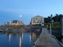
Chloe and I did an early morning tour of Lubec before getting ready for our ride today.  As we wandered down by the water, I realized that last night at low tide, the water was so low that you could almost have walked across the channel to Canada (or the other direction).  Interesting, huh?

Even though there isn’t a lot to do directly in Lubec, I enjoyed myself very much.  Besides the incredible scenery, everyone is so friendly.  As we walked around, almost everyone gave us a wave, especially the older gentlemen.

nb5

What I missed getting to take

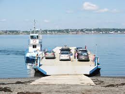
As I was getting ready to leave, I realized I was glad I found Campobello as I thought it to be one of the prettiest places I have ever seen.  Incredibly clean, very well-maintained, breathtaking scenery, hiking, fishing, swimming…what is there not to like.  In addition, during my drive around the island yesterday, I got quite excited when I found out there was a car ferry from Campobello to Deer Island NB which could cut out about an hour and a half of driving time.  I drove over to the ferry terminal yesterday to check it out only to be disappointed as they are not yet running for this summer season!  I was told that there was some issue with the boats.  Whatever…I had to drive.

So, today was rather tame as we were a bit tired after all the hiking and running around the last couple of days and it didn’t help that I didn’t sleep well last night.  It seems as I’ve driven north, I am waking earlier and earlier despite going to bed at about the same time.

nb2

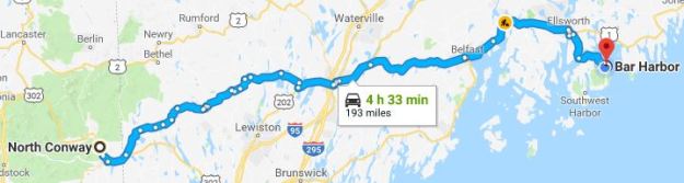
I drove up U.S. Route 1 north to Calais, ME where I crossed the St. Croix River into St. Stephen, New Brunswick.  So, since I was somewhat weary, I asked the border guard for his opinion and he suggested I take Canada Route 1, a four-lane divided highway, with a speed limit of 110 kph.  Also, once I crossed into Canada, I entered the Atlantic Time Zone which meant I am now an hour ahead of the Eastern Time Zone.  Maybe I’ll sleep an hour later?

nb3

NB1

Before I got to this roadway, I was driving through St. Stephen which was bustling in the late morning.  I noticed a Subway sign stating they have fresh lobster!  Then, more excitingly, I happened to see that St. Stephen is dubbed Canada’s Chocolate Town, primarily due to the Ganong Chocolate Factory and their annual Chocolate festival, so I thought this would be a good place to replenish my chocolate supply.

nb4

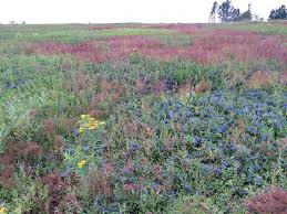
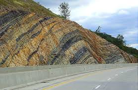
On my approach to Route 1, I saw a surprising sight which I have not seen in many, many years:  hitchhikers!  I’m hoping that it is safer to do this here in Canada than it is in the United States.  Anyway, I found that New Brunswick’s major highway, or at least this one, was rather beautiful as it wound through thick forests with periodic glimpses of the Bay of Fundy to the south, layered stone walls occasionally flanking the highway, and vast fields of wildflowers blending colors reminiscent of a Monet painting.  Very few billboards or signs mar the landscape and all roadway signs are in both French and English.

Luckily, my GPS converts kilometers to miles so that 110 kph converts to 68 mph.  I set my cruise to 72 and cruised along passing many but a few passing me so decided I was on the right track; then, a guy with Michigan plates blew by me so fast, I wondered if he thought 110 meant mph?

So, while I was still in Maine, on my way to Calais, I tuned in to an awesome radio station that played new and old country; I only mention this because it stayed loud and clear all the way until I got to Moncton!  No radio station in the U.S. stayed with me for anywhere close to 200 miles—I was amazed.  They are conducting a survey of their listeners about the potential that President Trump might impose a tariff on cars made in Canada and imported into the United States.  So, as I drove, I tried to think about what cars are Canadian and couldn’t think of one.  Ya got to love google because as it turns out, they don’t but some Japanese and American manufacturers do make their cars in Canada.

Checked into Crowne Plaza and what a lovely experience.  We walked in and literally, every employee came over to Chloe and scratched ears, rubbed belly, whatever.  They almost paid more attention to her than me.  They even insisted on watching her while I got our stuff from the car and said if I wanted to go out, they would dog-sit.

Now, I am here in Canada for eight days so I will have to buy gas.  I have seen that gas up here costs between C$1.243 and C$1.283 per liter so, if I have calculated this correctly, this converts to an average of about $3.63 per gallon American!

July 19, 2018 Still in Lubec, Mine

Cohill’s Inn, situated on the Bay of Fundy, offers just nine sleeping rooms; Chloe and I slept comfortably in Room 6, called the Lubec Channel room.  Beneath a high sloped ceiling, windows open to the fresh sea air, we huddled under a warm quilt as the day dawned at 5:01 this morning with a crisp 55-degree breeze blowing gentling through open window.

As I got ready to start my day, I was very perplexed when I noticed the time on my phone as 6:15 AM yet my computer showed 5:15 AM.  Strange, huh?  Well, apparently my phone thinks we are across the bridge in Canada where the time is one hour ahead.  When I look at google maps on my phone, I can clearly see that I am sitting in Lubec, ME so T-Mobile, what’s up with that?

Lubec14

Lubec13Whatever the time, Chloe and I were up, out, and about shortly after.  We walked all over this town, marveling at picturesque cottages, high up on hills overlooking the bay, churches with towering steeples, cozy little bed & breakfasts, quaint little eclectic shops, and the sea all around us. Construction seems to be going on all over…it looks mostly like remodeling, refurbishing, or just fixing up as opposed to new construction.  You can see Chloe gazing in awe at what lay before us.

Lubec12

We walked back to the room for a quick rest and a cappuccino, then decided to go further afield and got in the car.  Our first destination was the West Quoddy Head Lighthouse.   Despite its name, it is the easternmost beacon in the United States, one of only two still-standing U.S. lighthouses with red-and-white bands, and one of the first stations to be equipped with a fog bell and, later, a steam whistle.  A fascinating article about its history can be found here:  www.lighthousefriends.com.  The surrounding park is beautiful, and Chloe and I took advantage of some trails.

When we had our fill of this park, we drove around for a short while and then made a decision…

I mentioned yesterday that I almost drove into Canada by mistake.  Later yesterday afternoon, I purposefully drove in as I decided to make sure Chloe’s papers met their requirements.  I figured if there was an issue, I had two days to get it fixed.  I drove into Canada successfully and called Cindy and Jerry, my good friends and Causeway neighbors who reside in Canada, just to tell them I was standing in their country.  I didn’t stay long as I wanted to get checked in to my hotel.  But, I thought that the island was worth a visit.

Campobella

Campobello, a 15 square mile Canadian island in the Bay of Fundy and site of Franklin D. Roosevelt’s long-time summer home, lies 10 miles across open ocean from mainland New Brunswick but a mere 300 yards from the U.S. mainland at Lubec, Maine.  Well, I decided to go back to Canada on purpose and got in the short line to Campobello Island (part of New Brunswick) and crossed the Franklin D. Roosevelt Bridge.  After a few cursory questions about what we were carrying in the car, we were granted admission into Canada.

I quickly encountered the Roosevelt Campobello International Park, a combination indoor/outdoor site that includes the FDR summer home and a 1,133-hectare (2,800-acre) natural area. The Natural Area’s gravel roads offer you an experience similar to that enjoyed by the Roosevelt family when they came to Campobello. During that era, a system of carriage and surrey drives provided access to points of interest in what is now Roosevelt Campobello International Park or Herring Cove Provincial Park.  Top down, we explored the park’s many roadways (all extremely narrow and dirt or gravel) and even experienced some of the shorter hikes.  My car is filthy!

Campo8

We walked around FDR’s summer residence and decided to stop for lunch at The Prince Café in the park.  That salad you see is full of fresh blueberries, raspberries, and strawberries, pecans, and goat cheese, all topped with poppyseed dressing.  It was yummy!

We then decided to explore further and discovered the Head Harbor Light Station and, as we visited as the tides were coming in (at about 3:00 PM), we got these pictures.  Just so you know, today, at 5:29 AM the tides rose to an impressive 21.75 feet yet at 11:46 AM, low tide was at 2.30 feet so, as you can see, in a space of just six hours, the tides change almost 20 feet!  I can certainly understand the posted warnings about climbing down the ladders and walking across to the lighthouse.  If I didn’t have Chloe with me, I may have made plans to come back at extreme low tide to see about crossing (as long as other people were there with me.  I’m not brave enough to do something like that alone).  It’s probably just as well.

Driving back into the United States, I, of course, had to go through the Border Patrol gate where I found the agents (both yesterday and today) to be very friendly, informative, and welcoming.

Lubec15

So, I am here in Lubec for another night then tomorrow morning am off to Lutes Mountain in New Brunswick.  Chloe is completely out of it.  She crashed once we came back to our room and has been like this for the past hour or so—I guess she got a little too much exercise today.

Lobster

After Chloe napped for a while, we went down to dinner.  This inn’s restaurant reminds me a little of Martine’s in New Hope.  It’s a small bar with just a few dining tables but I’m not talking about appearances…it’s the ambiance and the friendliness one feels when you walk in.  Lots of locals show up and tourists such as myself are accepted and included in conversation.  The wait staff remembers you (and I have only been here one day) and it’s definitely a feel-good situation.  So, tonight, I ordered the lobster roll (I am in Maine after all).  Look at how much chunk lobster meat was included!  I know that today I walked more than five miles but if I keep eating like this, I’ll have to walk ten miles!

So, people in Maine use some unusual words but one in particular aroused my curiosity: “downeast”.  What does it mean and where did it come from?  On www.downeast.com, I found this explanation:  As Colin Woodard explained in his book The Lobster Coast, “the prevailing winds on the Maine coast blow from the southwest in the warm months, so ships from Boston were able to run downwind as they sailed along Maine’s north-easterly-trending coast.”’  Ok.  That may be an explanation, but I’m still confused.

Maine

Despite that, I found Maine to be a treasure with its rolling mountains, craggy cliffs, fishing villages, picturesque waterways, and the amazing array of seafood found everywhere.  Some interesting facts…Maine is both the northernmost state in New England and the largest, accounting for almost half the region’s entire land area. Maine is the only state to border exactly one other state (New Hampshire to the west).  It is also the easternmost state in the United States in both its extreme points and its geographic center.  Maine has the highest percentage of French Americans among American states and consider French to be their secondary language.  Maine is the least densely populated U.S. state east of the Mississippi River. It is called the Pine Tree State; about 83% of its land is forested, the most forested cover of any state.  I think I can attest to that last fact as I drove through Maine for many hours with the sweet smell of pine permeating my senses.

“Life must be lived and curiosity kept alive. One must never, for whatever reason, turn his back on life.”                 Eleanor Roosevelt


July 18, 2018 Lubec, Maine

Leg 17

Scenery wise—I don’t think today can be topped.  The day started out with a gorgeous sun brightening our azure blue skies with a delightfully cool breeze, a perfect day for the top down.  Acadia National Park was put in place to protect the natural beauty of the highest rocky headlands along the Atlantic coastline of the United States, an abundance of habitats with high biodiversity, clean air and water, and a rich cultural heritage. Each year, more than 3.3 million people explore seven peaks above 1,000 feet, 158 miles of hiking trails, and 45 miles of carriage roads with 16 stone bridges.

Acadia6

The primary avenue for navigating through this park on Mount Desert Island is the Park Loop Road, a 27-mile road that begins at the Hulls Cove Visitor Center (near Route 3 on the northern side of the island) and connects the Park’s lakes, mountains, forests, and rocky coast.  I had planned to drive the loop yesterday but with the heavy fog, figured I’d wait until this morning and I’m glad I did.  We set out shortly after 8:00 AM and the roads were already filling with hikers, bikers, bicyclists, and other drivers but luckily, the park provides many places to pull over and soak in the scenery.  I think you would have to work very hard to find any area that is not photogenic.

My only disappointment was that I would have liked to hike the trails as they look challenging and usually lead to sections of the park not visible from the loop.  Chloe is not the best hiker.  She seems game for about a mile but even then, she wants to investigate every smell, so it is slow going.

Once we left the park, our route today was mostly along Route 1 and, while much of the road surface could definitely use some repair, the views were mostly magnificent.  I must admit thinking that New Hampshire, with no sales tax and an income tax on interest and dividends (not earned income), somehow manages to have better paved roads than Maine, who has a 5.5%-8% sales tax (depending on what you buy) and an income tax on 5.8%-7.15% on all income.

Blueberries1

Blueberries

I discovered that Maine is one of America’s largest blueberry-growing states, raising 90% of the low-bush blueberries in North America. Sixty thousand acres in production produces a harvest of over 75 million pounds, the major proportion of which is raked in Washington County (which is where I am tonight). Many families from Lubec participate in blueberry raking. The prized, antioxidant-rich berries are harvested in the month of August and early September.  Blueberries and their products are sold everywhere.  Yum—love blueberries!  And, this is what I had for dessert tonight…blueberry crumble with freshly made blueberry ice cream–and yes, I already started eating it–Very good!

Lubec4

Driving into Lubec, I knew I was going to fall in love!  Located on a peninsula in Passamaquoddy Bay, slightly south of Eastport, it is the easternmost city in the U.S.A. and I am staying in the easternmost inn!

 Cohills In          Cohills1

The population as of the last census was 1,359 so it is a small town.  Settled in 1785 and incorporated in 1811, Lubec was once a proud and bustling sardine canning and fish-smoking center. It was here in the Quoddy region that America’s sardine processing industry was created.  Today, self-employed persons (many of them artisans) and the service industry seem to dominate the economy.

Our room is on the third floor (while that may be a slight drawback), we are experiencing a beautiful breeze off the water and we are high enough that no one can see into the room, so I can keep the windows open.  Air conditioning, while available, is not necessary.  Look at the views above—that, by the way, is Canada!

Lubec is a gateway to neighboring Campobello Island, New Brunswick Canada. Even Canadians cannot get there as easily as we can—there is a bridge from Lubec which I inadvertently almost crossed when I made a wrong turn!  (I had to do a u-turn to get out of line.) Canadians either have to drive to the U.S. and cross our bridge or they can take a ferry from Deer Crossing in New Brunswick to Campbobello.  Now that I know about this ferry, I may look into it.

Lubec3


July 17, 2018 Bar Harbor, ME

Leg 16

Before I even start on today, I realized late last night that I didn’t mention a very important place I drove through yesterday– Moultonborough, NH.  Why is that important, you ask.  Well, my good friend and Causeway neighbor, Cindy Taft, lives in Moultonborough when not living in Florida.  Shout out to you Cindy–beautiful place, bounded on the southwest by Lake Winnipesaukee and the northeast by Squam Lake, it looks to be a place with plenty to do.  And, did you know that (according to Wikipedia), Robert Frost and John Greenleaf Whittier both summered in Moultonborough…I’m guessing some of their poetry was inspired by their surroundings.

So, this morning, started out grey and a bit miserable, not completely conducive to a road trip but, my next stop was already reserved so I got everything ready to go as I usually do and, since I am an early riser, I was ready at about 7:00.  But, this morning, I waited to leave because I had heard that the included breakfast at the Old Red Inn was not to be missed.  Service began at 8:00 AM and I was privileged to sit with my neighbors (they were in Cabin 3 and I in Cabin 2), Susan and Ed from Weymouth, MA.  Great people!

Besides the normal juice, coffee, and tea, we were served a plate of cantaloupe and homemade blueberry bread.  Then, homemade french toast using thick slabs of delicious bread topped with fresh strawberries and creamy butter.  Definitely worth waiting for.

Chloe and I hit the road at about 9:30 and, if I thought I was immediately heading out of the mountains, I was very, very wrong.  I, of course, selected “No tolls”, “No highways” as I usually do but today, my GPS was sending me on routes North and sometimes West yet I knew that where I was going was south and east.  Adding to the directional conundrum were the twists and turns I was just not expecting today, especially in the rain.  Very little traffic, mostly alone in the forest , dark skies, grey mist hovering everywhere, swampy-looking ponds periodically lining the roadway…it was rather eerie and a tiny bit scary.

Other than the weirdness, my route today didn’t take me through particularly scenic areas.  I drove through many towns that look like any other town in America–Dollar Stores, fast food joints, gas stations, a church or two or four, houses without any distinction, maybe a little bar or restaurant.  Nothing remarkable but that was the luck of the draw with the route I selected today.

That isn’t to say I didn’t see beauty in my surroundings.  I drove through a tiny little town, Lovell on Kezar Lake that looked like I expected Maine to look. Waterford, Searsport, and a few other little towns were charming and quaint.  There has been a lot of fog or mist so I haven’t always been able to see much beyond the road I’ve been on.

bar9

Some amusing things…I saw a bunch of wild turkeys just hanging out on the side of the road–not even scared of the car.  There was a golf cart crossing on U.S. 202 where the speed limit was 55 mph!  The northeast seems to like roundabouts rather than traffic signals creating chaos for many (including me) who are not used to them.

Help wanted

One thing that just occurred to me that I haven’t mentioned before is the vast number of Hiring signs I’ve seen and I am talking about EVERYWHERE!  Signs on stores, billboards, advertisements on local radio, in local newspapers.  It is amazing to me how we have any unemployment at all!  One gigantic sign I saw was looking for stockers at their store, starting at $16.75 per hour with no experience necessary.  So, apparently, economically,  the country is doing well under President Trump!

Perez

Since I threw a little politics into my travel blog, I have to say one more political thing.  I am still very confused how our “intelligence agencies” have determined that the “Russians” hacked the DNC when the DNC has still not turned their server over to the FBI.  This is a fact.  On CNN (which I do not like), the interviewer asked Tom Perez this very question and he did not answer!  Interestingly enough, that interview cannot be found on CNN’s website (probably because it doesn’t fit their narrative).  But you can see it here:  American Mirror

Just so you know, I do believe that Russians meddled as they have done repeatedly throughout the years.  I am just questioning this specific charge.  How can they know without examining it, who in fact, hacked the DNC server.  Magic?

Anyway, Chloe and I arrived in Bar Harbor after traveling a number of miles on dirt roads (under construction) following eight motorcycles.  Strangely enough, they came to the same hotel!

Bar5

Bar6

Weather was overcast but that didn’t stop Chloe and I.  We went out exploring and finally stopped at Fish House Grill right on the water.  I ordered a cup of chowder, a lobster roll, and a glass of white wine.


Life isn’t about waiting for the storm to pass…It’s about learning to dance in the rain.  Well, we weren’t exactly dancing but we did walk in the rain…

Bar12


July 16, 2018 North Conway, NH

Leg14

This morning, Chloe and I took a nice long walk up around Magic Mountain, just reveling in the serenity of the locale.  Also, I decided to take my time leaving as I wanted to watch the happenings in Helsinki.  By 9:30 though, I realized that everything was running late and figured I’d get the highlights later on.  So, we loaded up the car and hopped back on Route 11 on our way to New Hampshire, one of the two states that was the original purpose of this trip.  New Hampshire and Maine are two of the six states I have never been to so, after this trip, I will only have Minnesota, North Dakota, Oregon, and Alaska left!

Chester

We drove through a beautiful and quaint little town, Chester, where many of the homes are very old, stately, and built of local granite, with glorious flower boxes adding spectacular color.  There seemed to be quite a few antique shops and art galleries.  Downtown was very inviting.

Claremont bridge

Before I even realized it, I crossed a bridge over the Connecticut River and I was in Claremont, New Hampshire.  Clean, tidy, and vibrant, Claremont has some beautiful churches and a neat bridge over a walking trail.  The highest point in the city is the summit of Green Mountain, at 2,018 feet above sea level in the northeastern part of the city.

Blithely driving along, I started noticing wildflowers of every possible color which was in stark contrast to Vermont’s greenery where even their flowers seemed to be shades of green.  It made me wonder why and no, I do not have an answer.  The roadways started winding and twisting up the White Mountains and the scenery spread out in front of me was majestic.  It seemed to me that more homes and towns exist in both Vermont and New Hampshire Mountains than do in the southern Appalachians.  Log cabins (the newer kind) effortlessly blend into the landscape, hidden driveways abound.

Moose

I kept seeing signs to watch for moose and I started wishing I was driving behind an eighteen wheeler since some of the roads crested with no sight line until reaching the top or curved up and around.  At one point, I think I may have seen a moose in the distance but am not positive.  The only time I was absolutely sure I’d seen animals bigger than those that scuttle along the ground was in Maryland when, right along side the road, two baby deer were grazing.  Never saw Mom and Dad.  Wonder where they were.

Seatbelt

By the way, New Hampshire does not have a seat belt law for adults; instead their signs say “Buckle up if under 18.”  There is no state sales tax and their income tax is 5% on dividends and interest but no income tax on earned income. I saw mail being delivered by a guy driving a camouflage jeep.  Despite the steep hills, I passed many bikers but this time I mean bicyclists.  At one point, I heard several gunshots which scared me just a bit but then I was driving in the forest.  Also, I have seen many sushi places in the mountains in New York, Vermont, and now New Hampshire which, frankly surprised me.

Live Free or Die

New Hampshire’s state motto is “Live Free or Die.”  Well, that sounds like a good motto…I guess they are all libertarians.

Driving along, we reached a stunning area surrounding Squam Lake. We had to stop to wander around for a little bit.  There are at least thirty islands in this lake.  I found out that the 1981 film On Golden Pond was filmed in the town of Center Harbor on Squam Lake.

We arrived at our hotel in North Conway and it is SO cute!  We have our own little cabin which is completely paneled and has its own fireplace.  I doubt I will need it but it is awfully charming.

Finally, I had to find out why this range within New Hampshire is called “White Mountains”.  They offer rugged wilderness areas and is still home to the world’s worst weather high atop Mt. Washington in the Presidential Range. The White Mountains were once called the “Crystal Hills” by the early settlers due to their granite faces that reflected sunlight in the valley below.

July 15, 2018 Londonderry, Vermont

Leg 13

Today dawned with skies angry and grey, raining pretty steadily.  I took the opportunity to lay in bed a bit longer than usual, reading.  I swear I think Chloe was just as glad.  She seemed a bit depressed after leaving Carol’s yesterday.  She had so much fun being un-tethered, getting to know Zoe, and chasing the cats.

I made myself a second cappuccino to savor as the deluge slowed to a drizzle.  By the time I was ready to move our belongings to the car, it was still dark and threatening but no moisture was showering down.  So, we got started at about 9:30.

Saugerties

As we do most mornings, we filled up with gas and, to my surprise, it was only $2.819 (less than in PA).  Our route took us back onto U.S. 9W-N and, while interesting, did not start out as scenic as driving north into Kingston.  The first part of this road was studded with rusted out cars and ramshackle houses but then cruising through a town called Saugerties, about twelve miles north of Kingston, the scenery improved.  The sun had broken through the clouds brightening the day and from what I could see, Saugerties is a cute village with tidy houses, ivy-covered cottages, religious statues and shrines surrounded by flowers decorating many yards.  The adorable Saugerties Lighthouse, on the Hudson River, rents out two guest rooms.

Rip Van Winkle

Further north, I passed by the Rip Van Winkle Bridge over the Hudson River between Hudson NY and Catskill NY.  I had told the GPS “Avoid Tolls” so my route kept me on Route 9W-N up through Albany.  It seemed as if every little town I passed through had a Family Dollar or Dollar Tree store and didn’t see a Walmart until I reached Albany.  My route took me through a pretty section of both Albany and Troy (I couldn’t really tell where one stopped and the other began) with well-maintained homes and beautifully tended flowerbeds.

Hoosick

I do know that once I crossed the Hudson, sunlight dappled through the leaves of trees adorning the sides of the highway as it meandered through the beginnings of the Green Mountains.  Before crossing into Vermont, I encountered a town, Hoosick, NY.  I saw this funky little deli and discovered that Hoosick Falls is famous since Grandma Moses, the artist, is buried there.  I found out that an art collector discovered several of her paintings in a drugstore in Hoosick Falls which he purchased in 1938 for $3-5 each.  Imagine that because much later, in November 2006, her 1943 work Sugaring Off became her highest-selling work at US $1.2 million.

Shortly thereafter, I passed into Vermont where I found that the Green Mountains are aptly named as a palette of varying shades of green greet the eyes in all directions.  The Green Mountains are part of the Appalachian Mountains, a range that stretches from Quebec in the north to Alabama in the south. The Green Mountains are part of the New England/Acadian forests ecoregion.  We arrived early so before we checked in, we drove around the area and did a little hiking in Lowell Lake State Park:


Vt park 7

Bar4

Magic Mountain is a ski resort located on Glebe Mountain in Londonderry, Vermont. It features a 1,500-foot vertical drop. The summit is at 2,850 feet and the base at 1,350 feet.  We’re staying at Upper Pass Lodge in a beautiful room with a deck which Chloe has been taking advantage of.  She is on the lookout for moose as we have been told they do travel in this area.

We went to dinner at the restaurant in the lodge.  The picture above shows just how pet-friendly this place is as Chloe sat with me in the bar.  I ordered shrimp scampi on fettuccine which was absolutely delicious; but, the best part was the lodge only serves Vermont beers or wines.  I tried three different vintages but my favorite was a crisp dry white wine with notes of apple, melon, and spring flowers.  This particular wine only used grapes grown in Vermont:  Lincoln Peak Vineyard Black Sparrow.  The pictures above, on the right, are Carol, the bartender and Vince, the innkeeper.

When researching Londonderry, I found an interesting fact that MAY connect our familial genealogy to this town.  Londonderry was first chartered in 1770 to a Col. James Rogers and was known as Kent, which included what is now Windham. The town was again chartered by act of the new Vermont Legislature on April 20, 1780. In this charter, the township was named Londonderry after Londonderry in New Hampshire, which in turn was named after Londonderry in Northern Ireland.

I am pretty sure that we have a Colonel James Rogers in the 1700’s in our ancestry.  Not sure at this time that it is the same one but wild huh?

July 14, 2018 Kingston, NY

Leg 12

Today’s drive was a mixture of highways and back roads taking me from Pennsylvania, through New Jersey, into New York.  Shortly after leaving Carol’s, I headed north on U.S. 202 when I quickly realized that I was headed towards one of my favorite towns, a place I used to live—New Hope, PA, a quaint, historic little town sitting on the Delaware River full of eclectic shops and top-notch restaurants.  Nostalgia overtook me, and I just had to take a quick detour.

Back in the summer of 1988, I was newly separated from my spouse, employed as Controller of The Matrix Organization in King of Prussia, and was traveling to New Hope on the weekends to visit my brother, Don.  Quite frequently, we occupied barstools at Martine’s RiverHouse Restaurant where we, together with other patrons partied, laughed, and solved world problems.  I got to know Martine pretty well and, to my utter surprise, one day she offered me a job as a bartender!  I told Martine that I didn’t know how to make drinks, but she told me personality makes the bartender, learning how to make drinks is the easy part.


That offer, and my ultimate acceptance, changed the course of my life.  I was having so much fun that, after several weeks, I quit my job at The Matrix Organization and moved to New Hope.  I got a cute little apartment near the towpath and, to help make ends meet, I got a second job.

John and Peter's

At John & Peter’s, I had to learn cocktailing in a crowded room while patrons rocked or swayed to music onstage.  According to their website, www.johnandpeters.com, since 1972, “For more than 4 decades we have featured live music seven days a week, 365 days of the year. That means we have showcased more than 48,000 musicians and entertained more than 640,000 guests since that first performance…. the longest running nightclub in the country dedicated to musicians who play original material.”

For the next ten years, I bartended in New Hope, Key West, Daytona, South Bend, and New Orleans.

Martine’s and New Hope look a lot different now than my memory from thirty years ago but I still felt the charm and quirkiness that I loved back then.

OLYMPUS DIGITAL CAMERA

I crossed the Delaware about seven miles north of where George Washington crossed so many years ago.

Port Ewen Bridge

Since I was still reflecting on my life, I barely noticed the New Jersey landscape  as I passed through into New York but that’s where my drive became interesting. I drove on the Palisades Scenic Byway eventually crossing through Bear Mountain State Park where, despite its name, I saw no bears.  Moving onto North U.S. 9 West, we rolled through Fort Montgomery which was the scene of a fierce Revolutionary War battle for control of the Hudson River.  We got out briefly and wandered around.  Further up the road, we saw signs for West Point; then, cruised through the darling little town of Port Ewen before crossing the bridge to Kingston.

So, we’re ensconced in our room when I heard a train whistle.  Looking out window, the Catskill Mountain Railroad train is crossing right across from our hotel’s parking lot.

Catskills train

Kingston, 91 miles north of New York City and 59 miles south of Albany, became New York’s first capital because, at the time, New York City was occupied by British troops and Albany (then the second largest settlement in New York) was under threat of attack by the British.  So, Kingston was considered safer.  However, the British never reached Albany but they did reach Kingston after the Battle of Saratoga and burned the city.


.

July 13, 2018 Warminster, PA

What a relaxing respite this has been.  Carol’s home is in a beautiful area, peaceful and quiet, marred only by the excited yapping of my little dog, Chloe, as she searches diligently for the two cats who reside here.  Chloe made friends pretty quickly with Zoe, the lab who also calls this home, but not with the cats, who have been smart enough to hide from this nemesis.  Chloe even figured out how to use the cat door as she charges in, out, and around, nose to the ground, in her quest to rid the premises of what she perceives to be the enemy.

Horsham fire (2)

Donnie, a paramedic and volunteer firefighter, was called out at 3:00 AM for a three alarm, multiple residence fire where one resident was critically injured and the first officer on the scene suffering from smoke inhalation.  After returning home shortly after 6:30, he barely had time to rest as he held a teaching session for several aspiring paramedics this morning.  He also attends college.  Donnie is one very busy, yet extremely focused young man.

While Carol participated in several video conferences with her employer, I read and got caught up on the news of the day, watching President Trump meeting with the Queen of England, and checking the status of my bank account and credit cards (as Carol has a secure WiFi connection).

Park 2

Park 1

Later on, Carol took me to Ringing Rocks Park, where, after a brief hike, we came to an opening in the trees where huge boulders and rocks, reportedly ten feet deep, cover about seven acres.  These are not just any rock; rather, they are sonorous rocks or lithophonic rocks that resonate like a bell when struck.  We brought a hammer and Carol proceeded to make music.  Several other people throughout the field were also but I believe to get the best music, you need a lot of hammering.  Listen to their beauty here:   Sound of Ringing Rocks

We also went to Nockamixon State Park, a beautiful area in Bucks County surrounding Lake Nockamixon, an artificial reservoir formed by a dam on Tohickon Creek.

But, the highlight of the day was the evening when Donnie III, Rebecca, Donnie IV, Becca, and a friend, Sam came over for dinner.  Carol prepared shrimp, broccoli and cauliflower drizzled with a balsamic reduction which Donnie III grilled.  We also had a  fresh salad popping with flavor. A great time was had by all!

Carol family

Carol family 2


July 12, 2018 King of Prussia and then Warminster, PA

Leg 11

I traveled today through some of Pennsylvania’s beautiful Amish country.  This was not completely a new trek for me, but I purposely drove in parts I do not believe I have previously traveled.  Amish people fascinate those of us who are so connected with all our devices and, I admit, I drove my car along these roads with a GPS tracking my travel, my smart phone providing me with music and available to google whatever question pops into my mind, and a recorder to keep track of thoughts as they occur.  Today, I am wearing brightly colored leggings, flip flops, and three earrings in each ear.

Amish live a much simpler life, without electricity, without our devices, without our ostentation.  Their clothing is plain and does not call attention to the wearer by cut, color, or any other feature.

I do not mean to say they are a curiosity to be examined.  In some ways, I think they are to be envied as materialism is just not in their DNA.  Also, from what I have read, they are extremely loyal to each other and that trait alone is one to be applauded.  The Amish hold humility as a highly-cherished value and view pride as a threat to community harmony. Just as the Amish do not carry personal photographs or display them in homes, they do not want others to take photographs of them.

This is their belief and I understand and respect their feelings on this subject.  For that reason, any pictures of Amish people I have posted herein are strictly ones I have found online and do not show anyone’s visage.  We could all learn a little bit about humility and simplicity from them.

I was surprised to find so much traffic, and how fast people drive, even on the various side roads.  There is so much to see–buggies, farmland, cottages, barns in towns named Bird in Hand, Intercourse, and White Horse. I even saw this miniature buggy pulled by a pony being driven by a child!

I was looking for roadside stands but, sadly, where there used to be many, I only found one.  I was able to buy some plump, juicy tomatoes and rum bread that looks scrumptious.  But, I was actually looking for one specific thing…dry bottom Amish shoo-fly pie.  For novices, I explain:  Though the ingredients and rough proportions of traditional shoo-fly recipes are more or less consistent regardless of the region, depending on how the crumb and molasses components are placed in the pie shell before baking, a shoo-fly pie will fall into one of two regional styles—dry-bottom or wet-bottom.  I found out later that I was in the wrong area.

Amish 8

For dry-bottom pies, generally the preference among shoo-fly bakers of the Lehigh County area of Pennsylvania, a portion of the crumb mixture is mixed or alternately layered with the molasses mixture in the pie shell and the remaining crumbs are layered on top. The result is essentially a crumb-topped molasses cake (a lot like gingerbread, sans ginger and other spices), enclosed in a pie shell.

Amish 7

Further to the south and west, in the Lancaster County area, the preference is for wet-bottomed pies, which are made by pouring the molasses mixture into the pie shell and gently spreading the crumb mixture, in its entirety, across the surface. The baked result is quite similar to dry-bottom shoo-fly with the key exception of the thick, sticky layer of molasses goo that forms between the cakey upper portion and the crust, adding another layer of texture and interest to the pie.

Note to Causeway followers: After I return, I promise that I will make this pie for everyone to taste!

Dawn

Once I finished my Amish country tour, I met my niece, Don Altemus for lunch at the Shake Shack in King of Prussia.  An incredibly pet-friendly restaurant, we each enjoyed a shackburger and shared an order of fries with bacon and cheese.  I ordered a pooch-ini for Chloe (ShackBurger® dog biscuits, peanut butter sauce and vanilla custard).

I then drove north to Warminster, PA to see my ex sister-in-law, Carol, and her grandson, Don IV (my brother Don’s grandson).  To my utter delight, Don and Carol’s son, Don III, and his wife, Rebecca also came over as did Don IV’s girlfriend, Becca.  Carol made us an absolutely delectable dinner of salmon with two different marinades and a salad.

This stop is, besides a wonderful visit with relatives, my first two-night stop.  YAY!  No driving tomorrow!


July 11, 2018 Lancaster, PA

Leg 10

I mentioned yesterday that it was raining when I found this Days Inn in Blairsville (about an hour east of Pittsburgh).  I must commend the innkeeper as he searched for and got me discounts to keep my price under $100; also, he accommodated my request for a first-floor room and told me Chloe looks like a service dog!  He’s getting a good review!

The only bad thing was the two vehicles parked under the portico thus requiring me to park in the rain so I managed to get completely soaked as I retrieved Chloe and our stuff from the car.  I couldn’t believe that I had gotten so cold I needed to put heat on in the room.  But, the heater worked fine so I was toasty in no time.

Gas

Yesterday (or was it the day before), I was bemoaning the fact that gas in Davis, WV was $2.959.  I never saw a price lower than that while in West Virginia or Maryland so succumbed and filled up.  I have made it a practice to fill up each morning as I have been driving on many “back” roads and don’t want to chance an issue with being low and nowhere near a station; this has sometimes resulted in my buying gas only to see it cheaper around the next corner.  Anyway, once I entered Pennsylvania, I started seeing prices well over $3.00!  It seems as if as I go north, gas prices climb.  I finally remembered the app, Gas Buddy, so I can at least get the best price available in the area.

20180711_080543

I told you yesterday about Chloe and I hiking up and down the streets of Pittsburgh, logging more than six miles.  Well, this picture was taken at 8:00 AM this morning—she is still tuckered out and is probably dreaming about riding in the car.  Poor baby.  I have to report that she also slept almost the entire trip to Lancaster.

So, this morning before I left, I examined several different routes I could take to get to Lancaster and decided on the one that went north through the mountains up by State College.  Today was clear and sunny so the views were clear and brilliant.  This road, while winding and at times steep, tended to have gentler curves than the mountain roads I drove in previous states and was frequently two lanes in either direction.  But, there was one pass where trucks were only allowed to go 20 mph downhill because of the slope.  In some of the sections where it was just one lane in either direction, there were big dots painted on the roadway with signs admonishing drivers to maintain two dots behind the forward vehicle.  Interesting concept that actually seemed to work.

Arch Rock 2

As with the other mountains I have passed through, the scenery was magnificent.  At one point I’d see a towering peak and a few minutes later, fertile farmland rolling alongside a stream.  I drove through an area called Arch Rock where you could see the multiple layers of rock out of which the road was carved.   I found out that construction to convert part of this highway from a two-lane highway to a divided, limited-access four-lane highway was completed in December 2007, and it includes building the longest mechanically stabilized earth wall in the U.S. (I read what that meant but found it somewhat dry and boring but, if you want to know what that means, read Mechanically Stabilized Earth .)  A good portion of the road followed the Susquehanna River and in the city of Dauphin, in the middle of the river is a miniature Statue of Liberty.

Susquehanna lady

I was curious and also fascinated so I looked up the story as reported by CBS News“No one in the town of Dauphin knew where it came from or how it arrived: in 1986, a statue of Liberty replica appeared on a piling in the middle of the Susquehanna River, off of Route 322. Traffic on the highway stalled from people who pulled over, slowed down, or stopped altogether to peer at the strange new landmark.  Though no one knew it at the time, a local lawyer had created the statue to celebrate the actual Statue of Liberty’s centennial celebration. He created it out of Venetian blinds and plywood, and with a group of friends he erected it in the middle of the night. Though the statue’s origin remained a mystery for years, eventually the creator came forward and revealed himself. In the 1990s, the original statue was destroyed by weather. By that point, the residents of Dauphin had grown so fond of their miniature Lady Liberty that they raised enough money to build a new one: a larger, more durable, more securely-fastened version.  The second Lady Liberty is the one that remains to this day. She stands 25 feet tall and greets all who pass through Dauphin.” 

Cop stop

As Pennsylvania is the state where I did a good portion of my growing up, I am happy to be back for a short while but there is one thing I’ve noticed that sort of frightens me.  Since July 2, I have driven in nine states and I believe that, in Pennsylvania, I have encountered the rudest, most self-centered drivers so far.  They don’t seem to move over while someone is merging, they speed up when you put your turn signal on to move to a different lane, they turn without using signals.  Most of the time, this was behavior I observed rather than having it directed at me but I saw it quite frequently.  Anyway, I saw this one guy in a rather tricked out red pickup guilty of all the above as well as weaving.  I must admit, I felt very gratified to round one of the mountainous curves and see him pulled over.  Karma.

So, I am staying the night in Lancaster because I plan to tour the Amish country back roads on my way to King of Prussia tomorrow.  Did you know that Lancaster was Pennsylvania’s capital from 1799 to 1812 and almost became the nation’s capital?  Hundreds of historical landmarks remain, and it boasts the largest National Historic Register District in the United States.

Finally, today is 7-11 an I am in the land of Wawa!