Category Archives: New England & Canada

July 10, 2018 Pittsburgh, PA

Leg9 9

Do you remember the movie “If it’s Tuesday, this must be Belgium”, well, I am sort of on a whirlwind trip having spent only one night in each of, thus far, eight locations.  Tonight, my ninth, was to be in Pittsburgh and today is Tuesday.

So, I woke today knowing that I was on my way to visit Tina Rogers, my beautiful niece, daughter of brother John.  Tina is a junior at the University of Pittsburgh, majoring in engineering.  It is summer, and she has chosen to stay in Pittsburgh working as she is in a program where you get a year of experience while attending college.  What a great idea!

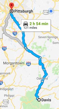
I had a choice of several routes but chose to continue driving on US 219, even though it was slightly longer than the other routes.  I decided on this route because it closely follows what is known as the Seneca Trail.  I had read an article called The Seneca Trail which describes it best:

Seneca Trail

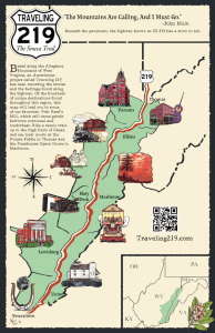
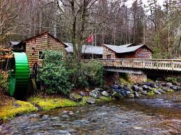
“Traveling Route 219, one passes through scenery of local life rich with history. A hot dog stand from the 50s, a 19th century mill whose great wheel still grinds grain, a stone proclaiming the boundary of Lord Fairfax, small stands of virgin hemlock; these are places that point back in time. One comes to sense it: sections of this road are deeply worn. The route it followed through West Virginia was an old one, and well-traveled.  Long ago, it had been a major Indian footpath.  The Seneca Trail, known also as the Great Indian War and Trading Path, was a part of a network of trails stretching from the Deep South to modern day New York that was used by the Catawba, various Algonquian tribes, the Cherokee, and the Iroquois Confederacy.”

I was very happy to see that Route 219 crossed into Maryland, which is the only time I will enter that state on this trip.

I lived in Maryland as a young child and visited the state many times throughout my life so didn’t feel it necessary to stay there but I am glad that I drove through the western portion as my experience had been primarily eastern Maryland.  Similarly, with Tennessee—I never lived there but I’ve been to Nashville and Memphis more than once and attended fabulous family reunions in the western portion of the state.  So, I enjoyed seeing the vastly divergent topography.

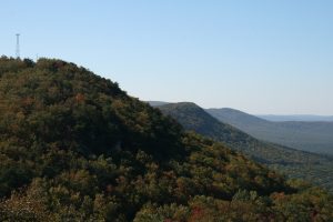
In Maryland, I drove through rural landscapes, small towns and numerous state parks including this stunningly beautiful town on the edge of Deep Creek Lake, Maryland’s largest freshwater lake.

Tina

I arrived in Pittsburgh at about 1:00 pm after driving about four hours.  Anyway, when Tina and I spoke last night, Tina told me she has three roommates (and all of them are working and/or going to school) so, even though she kindly invited Chloe and I to stay with her for the night, I decided that a hotel made more sense.  Despite the $225 cost exceeding my usual hotel budget, I wanted to see Tina so reserved at the hotel closest to her apartment (which proclaimed frequently on its website that it is “pet-friendly”).  When I arrived, they wanted to charge me $150 pet fee plus $20 to park!  I decided that I just could not tolerate that.  Most hotels, if they charge a fee, charge $10-$25.

So, I tried finding another hotel but couldn’t find one unless it was pretty far away.  I decided that it made more sense to just have dinner and then leave Pittsburgh and get a hotel out of town.  Chloe and I had several hours to kill before Tina got off work, so we walked up and down some of the steepest streets I have ever climbed.  We walked a little over six miles today!

Pitt food

Tina finally arrived, and we went to the Union Grill.  Tina ordered a seafood burger with lemon cilantro dressing and I ordered their signature dish, Turkey Devonshire (which was reviewed favorably by “Taste of America” on the Travel Channel.  It is slabs of turkey, covered with thick slices of tomato, covered with cheese sauce and bacon, served over toast points.  Very good but WAY too big.

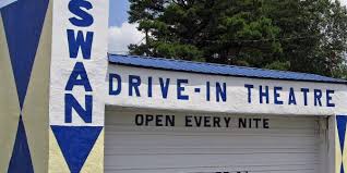
So, after a satisfying dinner, I left Pittsburgh with the thought that I would stop somewhere once outside the city.  My decision was made when it started raining in Blairsville.  So, here is where we sleep tonight.


July 9, 2018 Davis, WV

Leg 8

When I left this morning, I figured I’d take the interstate for a while and, after about an hour, I was in such a zombie-like zone that I realized I could not stay on this track any longer.  So, I got off the interstate and changed the GPS to “No Highway” and “Scenic”.  OMG!  So much better.  The new route added almost an hour, but it was definitely worth it.  The mountain roads in this part of West Virginia are very well-paved and marked.  While there didn’t seem to be as many sharp switchbacks as I experienced in North Carolina, there were frequent steep slopes of 7% with warnings for trucks.  I even saw several run-offs for trucks should they get out of control.  I used to see that a lot when I was living in Utah.

Windmills 33

But, the really special thing was the diversity.  Many of the roads were completely canopied by trees with sunlight winking through the leaves or completely rimmed by moss-covered rocky slopes.  As is becoming usual on this trip, when the road circled the outside of the mountain, the views were awe-inspiring.  There was one point (I think I was on WV-33) when the range in front of me sported majestic windmills as far as I could see.

Driving on secondary highways also gives one a glimpse of how others live.  I drove through Fayetteville, WV which claims to be “the coolest small town” and it did look vibrant and worth visiting.  Fayetteville is where I passed over the New River Gorge Bridge, built in 1976, which, at the time, was the world’s longest arch bridge.  It is one of the world’s highest vehicular bridges in the world and is depicted on the back of the West Virginia quarter minted in 2005.

New River Gorge

Many small towns are tucked away in these mountains and oftentimes, you can see a lone house sitting atop a hill with a steep, curvy driveway.   Something else I saw here in West Virginia, which I also saw in Florida, were teams of inmates cleaning and pruning the roadways.  What a good idea.

20180709_163512

So, now, we are in the mountains directly on the Appalachian Highway at the Canaan Village Inn in Davis, WV.  It’s a good thing I planned on today being a relaxing day.  I picked this town as a way-point strictly because I am on my way to Pittsburgh and needed a mid-point, found a hotel, so that was that.  I wasn’t looking for a touristy town nor a place with anything in particular to do.  To be honest, I never even looked at things to do until I got here.

Davis is, at an elevation of 3,100 feet, the highest of any West Virginia town.  But, it is a town of only 1.83 square miles with a population of 660 people at the last census.  The area surrounding Davis is known for its mountain biking trails and one of the annual races, The Revenge of The Rattlesnake, is considered one of the toughest bike races in the country.  Their most notable citizen is Frankie Yankovic, considered to be America’s Polka King, was born in Davis, WV.

We sat outside for a while enjoying the mountain air.  It is gloriously cool with a gentle breeze; I read while Chloe watched the world around her. There are fields and a pond with ducks that Chloe wants to explore.  I can see a general store across the street with gas at $2.959—yikes!  Also, miniature golf and two restaurants plus this inn I’m in.  Not much else.

Chloe in room

The room is cute, with the requisite king-sized bed, refrigerator, microwave, coffee maker, an adequate desk area, and direct tv with hundreds of channels including the main one I watch (Fox News).  The owners told me they used to live in Jacksonville but decided to come home to Davis, WV and buy a business here.  I must say, there is something to be said for living in a small town.  They know everyone and they all help each other out.  I found this to be true first hand.

The Inn’s ice machine is broken so the owner told me the store across the street has ice.  I needed perhaps an ice bucket full and their smallest bag was 22 lbs.  Now, I do not mind paying $1.99 for a bag of ice but I hate waste so, I mentioned why I needed ice and she went to the back of the store, got a quart-sized cup, filled it with ice and gave it to me.  I had to practically force her to take $1.00 from me.  You gotta love the small-town solidarity.

So, my final thought for this evening…this morning at 8:00 AM, I realized that I have now been on the road for a full week.  I’ve driven through Florida, Alabama, Georgia, South Carolina, North Carolina, Tennessee, Virginia, and West Virginia many times in my past.  But, for this trip, I’m seeing completely different geography than I’ve seen before as I’m driving in different parts of the states.  It is fascinating and even quite educational.  I’m loving it!

July 9, 2018 Still in Princeton, WV

I woke up this morning and it is only 51 degrees here in the Appalachian Mountains.  I had to turn on the heat in my room!

Anyway, I will be packing up soon but wanted to share a picture I received yesterday from Aaron Mermin-Heslin.  He and his wife, Laura, were together with Rick, Mary Pat, and I in the Amazon jungle in Peru back in May.  You may recall our talking about being taken by our guide to the middle of the Madre de Dios River and loaded into a rubber raft.  Aaron and Laura were loaded into a separate raft.  Then, the guides all left us.  Well, Aaron sent me a picture he took of Rick, Mary Pat and I floating down the river.

Peru river (2)

July 8, 2018 Princeton, WV

By the way, I had to post two maps above because Google Maps does not seem to recognize the Blue Ridge Parkway.

Today dawned bright, sunny, and chilly…a beautiful day for a drive.  Since the Blue Ridge Parkway entrance was less than a half mile from the Skyline Village Inn, I decided to drive north on that roadway for a while.  Predictably, it was beautiful, especially since the sun kept everything bright and I could still see the morning dew glistening on plant leaves.  I even put the top down as the speed limit on the Parkway is only 45 mph and since the morning temperature was in the low 60’s, I used my seat warmer.  This was the first time I had put the top down for any length of time and it was amusing watching Chloe’s reaction.  She kept looking up as if completely confused but, good traveler that she is, she stayed in her seat.  Of course, I did have her tethered to the doggy seat just in case.  😊

Anyway, before we even left the hotel, I had sort of made the decision that I had driven enough twisty, curvy mountain roads for a while and was going to shorten my trip a bit by taking some highways.  So, after a little more than an hour, we left the Parkway somewhere around Linville, NC.  The GPS route ended up taking me through an adorable little town called Minneapolis in North Carolina.  Despite being barely a dot on the map, it was so full of American flags that I took notice.  I looked the town up–its population is 376. I think the flags outnumbered the people!  On this same road I saw a sign “Enough about gun control.  What we need is idiot control.”  A little further on, a sign proclaimed “Every man dies.  Not every man truly lives.”

And then, after those profound statements, I was listening to a radio station where the hosts debated whether there was a difference between soul food and Southern food other than the skin color of the cook.  I listened to their yammering for almost ten minutes before I finally just turned the radio off.  As I was writing this blog, I decided to google the question and here is one answer:

Trying to differentiate soul food from Southe­rn food is a bit complicated. While not all Southern food is considered soul food, all soul food is definitely Southern.  So, there you go.  If you want more details about this very important topic, you can read Ultimate Guide to Southern Food

Roan Mtn

Shortly after this, I entered Tennessee and continued through the Roan Mountain State Park which is within the Cherokee National Forest.  More spectacular scenery.  When I reached Bristol, TN, the speed limit reduced to 35 mph but I didn’t mind since I could look around as I drove.  This is why I usually avoid interstates—I like to see what is around me.  I passed the Bristol Motor Speedway—good thing no events scheduled today and I discovered that Bristol has been recognized by Congress as the birthplace of country music!  Pretty town.  Before I knew it, I was in Bristol’s sister city, Bristol, VA where I jumped on I-81.

tunnel

I usually avoid interstates as I find them boring without a lot of interesting scenery but occasionally, they serve a purpose (like going under a mountain).  I passed a place called Mt. Rogers, which, as it turns out, is the highest natural point in the Commonwealth of Virginia.  The mountain is named for William Barton Rogers, a Virginian educated at the College of William and Mary, who taught at William & Mary as well as the University of Virginia, became Virginia’s first State Geologist, and went on to found the Massachusetts Institute of Technology.  I don’t have access to my genealogy software right now but I do not recall him as an ancestor.

Also, I saw signs for a place called Hungry Mother State Park; curious about the name’s origin, I found this story on http://www.dcr.virginia.gov/state-parks/hungry-mother#general_information :

“A legend states that when the Native Americans destroyed several settlements on the New River south of the park, Molly Marley and her small child were among the survivors taken to the raiders’ base north of the park. They eventually escaped, wandering through the wilderness eating berries. Molly finally collapsed, and her child wandered down a creek. Upon finding help, the only words the child could utter were “Hungry Mother.” When the search party arrived at the foot of the mountain where Molly had collapsed, they found the child’s mother dead. Today, that mountain is Molly’s Knob (3,270 feet), and the stream is Hungry Mother Creek.”

Denver2

Denver1

After about seventy miles, I switched to I-77 North into West Virginia.  So, now I am in Princeton, WV after traveling in four states today.  I am actually staying on the outskirts of town near the Walmart (that part wasn’t planned) but I contributed to the local economy by shopping there for Chloe and getting a takeout dinner for me from Outback.  We had gotten here pretty early so drove around and the town is kind of nice.  I found out that Bob Denver adopted Princeton, WV as his home (remember  Maynard G. Krebs from Dobie Gillis and Gilligan from Gilligan’s Island).

Anyway, Chloe and I decided we needed a nice relaxing Sunday so basically, she’s doing her favorite thing (see picture below), and I have been reading…one of my favorite things to do.

20180708_170706


July 7, 2018 Little Switzerland, NC

Leg 6

Last night a wicked storm cropped up while a bunch of us “residents” at the motel in Bryson City were drinking a few beers and conversing out on the porch in front of our rooms.  The other members of this little group were bikers and, as many of you know, I was a member of that culture for a portion of my life, so I felt at home with them.  We traded stories and laughs until the storm forced us inside.  I was tired at this point anyway so was ready to call it a night.

This morning was grey and gloomy, also a little chilly (62 degrees) but I was set to drive the Blue Ridge Parkway to Little Switzerland, NC.  It was drizzling, and visibility seemed to be okay, so I took off at about 8:00 AM.  Unfortunately, conditions deteriorated while on one of the many North Carolina Smoky Mountain roads.  What started out as wisps of fog appearing to occasionally drop down from the sky became more frequent as the road because more treacherous.  At one point I and two pickup trucks were in the midst of about 40 bikers and, it was so bad, none of us were driving the speed limit of 45 mph.  When we finally came to a little town, I decided to pull over for a bit and catch my breath.

Pkwy 3

I was a bit lost as I had been just following people rather than paying attention to the GPS.  I figured as long as I was going in the general direction of my destination, what difference would it make.  So, I took Chloe for a little walk, drank some water, and then got back on the road.  At this point, I still hadn’t driven on the Blue Ridge Parkway as I had missed the entrance at Cherokee and my GPS stubbornly refused to find it.

Diamondback

So, after this little time out, I decided to just follow my GPS instructions and worry about the Parkway later.  Some of the ride was uneventful but then, I encountered the Diamondback.  Of course, I didn’t know that at the time; I just knew my GPS was taking me on Route 226-A.  Oh my God!  I cannot describe it any better than this description from www.blueridgemotorcycling.com :

“Just outside Marion, NC, The Diamondback – NC 226A – has more than 190 steep, climbing curves in just 12 miles. The temperatures cool as you climb the steep switchbacks looping almost 360 degrees. Runs of S-curves climb and twist sharply as they snake through lush green forest en route to the Blue Ridge Parkway just above Spruce Pine, North Carolina.

At its peak, The Diamondback joins the Parkway above Little Switzerland, NC. Expansive views of the mountain valley, shopping, dining and beverages, plus full-service accommodations and recreational amenities are available at Milepost 334.

Half the fun is getting there via The Diamondback – NC 226A. Sweeping curves, amazing scenery and cool mountain breezes make The Diamondback, NC 226A, a quick, fun route to North Carolina’s Blue Ridge Parkway.”

Pkwy 2

Pkwy 1

It was scary!!!!  But, I finally found the Blue Ridge Parkway which I followed to my hotel–the Skyline Village Inn.  I was too early for check-in so decided to get back on the Parkway and head towards the highest elevation east of the Mississippi—Mount Mitchell.  While everything is lush and the scenery breathtaking, the intermittent but frequent fog obliterated most of the pictures I took. Also, even though it didn’t rain hard at any point today, the constant drizzle kept everything so wet that I wasn’t in the mood to hike, especially with Chloe.  So, we stopped at overlooks and campgrounds to check things out.

Skyway Village Inn


We headed back to our hotel and discovered what may be my favorite hotel/inn ever–what an absolutely charming place!  The Inn has only sixteen guest rooms, beautiful marble floors, 22 kinds of hardwoods and tables made of thousands of inlaid pieces of wood using a technique called parqueting.  Our room is all handmade hardwood walls and floor with a built-in desk, a comfortable queen-sized bed with lots of pillows and we are two steps away from the deck with a sweeping view of the valley and mountains beyond.  The inn proudly welcomes bikers and dogs and there is a restaurant on premises strictly for the guests.

From hotel

View from hotel

So now I must talk about the restaurant.  First off, remember, this place only serves the guests; what a novel concept.  So, those of us in the eating room all had something in common and there was a lot of talking among tables.  There was a group of women bikers from Florida and other biker couples from elsewhere.  There were also other couples traveling with dogs!  We exchanged opinions about the area and the food.

Based upon recommendations, I ordered the crab cake with two sides and a glass of sauvignon blanc.  I was planning on having their homemade key lime pie for dessert, but they ran out.  Rather than getting a different dessert (I did consider the bourbon pecan pie), I decided to have another crab cake—it was that good.  I mean this crab cake was in the same class as Mom’s crab cakes.  The owner (the chef) did not serve the crab cake with a sauce that would overpower it; instead, she suggested a light hot sauce and OMG, was it ever good.  I selected cole slaw and potato salad as my sides and they were just as delectable.

So, after being completely satiated, I went back to the room a while later, walked Chloe, and am now settling in for the night.  I love this place and recommend it to everyone!


July 6, 2018 Bryson City, NC

Leg 5

Today started out the same as it has every morning.  I woke at around 6:00 AM, made a double cappuccino, turned on Fox & Friends, and lay in bed reading while sipping my morning libation.  Also, as usual, Chloe slept in.  After a while, I got up, showered, dressed, went to the breakfast room for some fresh fruit.  Then, at about 7:30, took Chloe out for a walk.  This morning we were met with what looked like an impenetrable opaqueness, fog so dense that it seemed as if we were on an island in the sky.  The Blue Ridge hotel is on an overlook that yesterday offered a magnificent view, today completely obliterated.

On previous days, I have been enroute sometime between 8:00 and 8:30 but even though my route today is less than two hours, it was through the mountains, so I was reluctant to embark during these less than favorable conditions.  I made my second cappuccino and I finally decided to leave once I was able to see into the valley below which happened at about 9:30. I’ve mentioned the winding roads I’ve experienced on previous legs, but today’s route was definitely the best.  This was NOT a road to be driving without complete concentration.

Nantahalla

While I was driving along, I experienced a bit of confusion concerning how I managed to get from Georgia to North Carolina without going through South Carolina; I finally was able to clear up this conundrum when I checked out the map and found a small corner of northeastern Georgia bordering North Carolina.  The ride through Nantahala National Forest was breathtakingly beautiful, narrow roads surrounded by towering trees with the leaves reflecting dappled sunlight.  A good portion of the road ran along side a river where occasionally I glimpsed rapids, so it made sense that there were many places offering tubing, canoeing or white-water rafting.  As we were in the mountains, I also saw signs for zip lining.  What did surprise me were the number of places I saw offering paintball!

Throughout my trip thus far, I have experienced some difficulty finding radio stations that remain clear so use my scan feature a lot.  On the trip today, one FM station came in loud and clear and, it turned out it was based right here in Bryson City, basically a Christian station with call ins but usually playing gospel music.  Seemed fitting to listen while driving through this woody heaven.

Bryson 3

This was a short trip, planned because I want to drive the Blue Ridge Parkway starting in the morning.  Bryson City, picked by me purely because of its proximity to the beginning of the Parkway, turned out to be a delight.  Bordering the southern side of the Great Smoky Mountains National Park, Bryson City is a laid-back, non-touristy town of 1,300 with more stop signs than stoplights. I found it to be an easily strollable town with local bookstores, arts and crafts galleries with working artisans, bike shops, a fly fishing shop, a historical museum, a fly fishing museum, a scenic train, a brewery, and a surprising variety of restaurants.  The eastern side of the town borders the reservation of the Eastern Band of Cherokee Indians.

Bryson 1

Bryson 2

We experienced a gorgeous sunny day with gentle breezes so Chloe and I spent several hours wandering around, gazing at ducks paddling by on the Tuckasegee River (this was directly behind our hotel), eating ice cream at a local creamery, and sitting on rocking chairs watching a stream of bikers cruising through town.  Another thing I noticed is that the town is clearly influenced by the Cherokees as there are plaques all over praising their supportive role during the Civil War; Cherokees were famous for their skill and persistence in tracking escapees and bushwhackers. And, yes, there are monuments here!

I found out that Bryson City was featured by Smithsonian magazine as one of “20 Best Small Towns to Visit (2016); one of “20 Best Mountain Towns in America” (2017) by Mens Journal; by Backpacker magazine as one of 12 US “Top Hiker Towns” (2016); voted by Trip Advisor readers as one of “8 Beautiful Little Lake Towns Across America.” (2017).  Cool, huh—and I didn’t even know this when I planned this town as one of my stops!

Finally, the funniest saying I saw today:  “Men are like cow chips.  The older they get, the easier they are to pick up.”


July 5, 2018 Blue Ridge, GA

Leg 4

We are back in the Eastern Time Zone in Blue Ridge, GA, which sits on the divide between the Tennessee River to the north and the Alabama River to the south, as well as being surrounded by the Blue Ridge Mountains near the southern tip of the Appalachian Trail. The city is the county seat of Fannin County and consists of 2.2 square miles with a population of 1,290, according to the 2010 census.  Their claim to fame is they are the trout fishing capital of Georgia.  I’ve never eaten trout but perhaps I will try it here.  Anyway, this county is in the extreme northern part of Georgia bordering Tennessee.

Driving here was a challenge.  Yes, we encountered winding and hilly mountain roads and that part was exhilarating.  I love driving winding up and down roads!  What was not fun was the lack of signage causing several wrong turns.  Yes, I use I GPS but when you come up to a multi-faceted intersection and signs aren’t clear, there is a lot of room for error.  Mountain roads do not have shoulders and trying to turn around is an impossibility.  I let GPS tell me how to get back on track and one time ended up on this harrowing, narrow, extremely STEEP, curvy gravel road with drop offs that were very, very scary.  My little VW Beetle was not happy with this road.  Also, the roads I traveled on in the Georgia portion of this trip were not as well maintained as in Alabama.

So, we got to Blue Ridge, GA at about noon and, despite requesting early arrival, my room was not ready, and I was told it wouldn’t be ready until 3:00 PM.  Despite that, they did give me access to their breakfast kitchen so I was able to get my handy little cappuccino maker and made myself a much-needed coffee and give Chloe some water.

Blue Ridge MtnsAfter this rejuvenation, we decided to explore.  The downtown area is less than a mile from the hotel but, due to the lack of sidewalks and the narrowness of the roads, it was suggested that we not walk.  So, first we toured the area by car.  Beautiful vistas greeted us at every turn, but Chloe and I wanted to do some walking, so, after a while, we headed downtown.

Blue Ridge train

I was surprised to see FREE parking at the base of Main Street which I could see was packed with people, probably mostly tourists.  The downtown area boasts quite a few quaint shops and eclectic restaurants which line Main Street. Also, tracks for the Blue Ridge Scenic Railway bisect the downtown area, with the Scenic Railway itself operating out of the town’s historic 100-year-old Depot.

By the way, I found out that Blue Ridge is also home to one of the five remaining drive-in theaters in Georgia, the Swan Drive-In Theatre.  According to my research, there are only 336 operating drive-in theaters left in the USA whereas, in the 1950’s, there were about 4,000.  I’m surprised as I thought they were all gone.  Ah, the memories!!!  Kids today don’t know what they are missing.

drive in

Chloe and I ambled along the street window shopping where, to her great delight, she got a lot of attention; we noticed that almost every shop had a doggy water bowl which Chloe immensely appreciated. We were about half way down the street when I realized that Chloe was saving me a lot of money because these were my kind of shops—so many unique items!  Anyway, I wasn’t really lamenting not shopping as I don’t need anything, so we were just taking our time walking along when suddenly, I hear someone yelling “Catie, is that you?”  I looked over and it was Brenda Buck—one of our Causeway neighbors!  It turns out she has a home up here.  What an incredible treat it was to see a friend so unexpectedly.  We visited for quite a while and then Chloe and I continued our trek.

cappuccino

By this time, it was well after 3:00 PM so we headed back to the hotel, checked in, and I made another cappuccino and read for a bit. Chloe took a nap and, for the first time ever, she snored!

After resting up for a while, we drove back to Main Street to eat dinner at one of the many pet-friendly restaurants here in Blue Ridge.  I think I found the best, “Harvest on Main Street” where they say they specialize in “southern inspired global cuisine”.  I ordered Wild Caught Georgia Shrimp & Logan Turnpike Grits, with House-Made Tasso Ham, served with cornbread.  YUM!!!

Harvest Blue Ridge

Harvest on Main Street


July 3, 2018 Oxford, AL

Leg 3

Chloe and I are still in the Central Time Zone but now on our northern trek.  We are presently in Oxford, AL.  As I was leaving this morning, I admit that I was not looking forward to this drive.  When plotting my route, I was to head up to the Blue Ridge Parkway from Navarre, but, since the distance was greater than I was willing to drive in one day, I knew I needed a stopping point.  I had quite a bit of trouble figuring out where exactly to take a rest but finally decided to trade a long drive today for a short one tomorrow.  My expectation was that the drive would be somewhat boring, yet, surprisingly, it turned out to be quite challenging and very interesting.

ar

Before I get to today’s trip, I completely forgot to mention something yesterday.  Kevin showed me pictures of BEARS roaming in his neighborhood.  I was a bit skeptical, but he showed me video.  As further proof, you can click on this article from the June 5, 2018 WKRG News 5!  Can you imagine?

Ok, back to the trip today.  It turned out that most of the route was somewhat winding and hilly, truly a fun driving experience.  It was not busy at all, most of it 55 mph or 65 mph, and very nicely maintained with good signage.  Northwestern Florida is picturesque with forests and rolling hills through the Blackwater Wildlife Management Area.  There may not be mountains in Florida, but I drove near the highest elevation point in Florida—Britton Hill, 345 feet above sea level, located near the town of Lakewood, FL.

Then, following the “Sweet Home Alabama” sign, we drove through a charming little town featuring homes sporting wraparound porches, perfectly manicured lawns, with almost all of them proudly displaying American flags.  Fittingly, at the time, I was listening to a country music station playing the best patriotic songs ever…made me proud to be an American.  I managed to keep that station for over two hours and didn’t even realize so much time had gone by since I was so busy singing and driving.

I’ve driven across or around this vast country several times and I am always amazed at how beautiful and lush it is.  Alabama did not disappoint—farms stretching out as far as the eye could see, twisting and meandering roads snaking through the Talladega National Forest, majestic mountains, glistening lakes, and gurgling rivers.

Talladega

I lost my country music station but found one re-enacting the founders voting to approve our Declaration of Independence as well as a complete reading of the Declaration.  It was riveting!  Did you know that the Declaration was originally presented to Congress on June 28, 1776.  Debate began on July 1 but because Congress thought it of the utmost importance that independence be unanimously proclaimed, they delayed the final vote until July 2, when 12 colonial delegations voted in favor of it, with the New York delegates abstaining, unsure of how their constituents would wish them to vote.  John Adams wrote that July 2 would be celebrated as the most memorable epoch in the history of America. Instead, the day has been largely forgotten in favor of July 4 which is when Thomas Jefferson’s edited Declaration of Independence was adopted.  Interesting.

Back to Alabama…I did see some amusing things during my drive.  There was a store advertising “Drugs, Guns & Gifts” and another “Boiled Peanuts and Fine Wines”.  I saw lots of flags, several signs with the message “Honk if you support the military”,

Oxford is pretty much centrally located between Atlanta and Birmingham, lying among the foothills at the southern end of the Blue Ridge Mountains.  Nearby is Cheaha Mountain, Alabama’s highest point which offers expansive views of the surrounding wilderness and the city below. Much of the city’s southern border is shared with the Talladega National Forest.

Interesting facts:  Kwon Alexander, linebacker for the Tampa Bay Buccaneers, was born and raised here and he attended high school with Miami cornerback, Robert Marcellus McCain. Gas is averaging $2.45 today here in Oxford which is $ .14 less than in St. Pete and $ .26 less than in Navarre.

So, I did a bit of research and apparently, “Lick Skillet”, as Oxford was originally known, was settled about 1830, soon after the Indians left the area.  Old timers say the name “Lick Skillet” came about when a traveler stopped at a store in the little hamlet and asked where he could get a meal.  He was directed to a shoemaker named Edge who, in addition to making shoes, furnished meals to travelers.  When the man again returned to the store, he was asked whether he had found anything to eat.  He replied that he had, but that he had to “lick the skillet.”

This is one of the best hotel rooms I have ever had–it is so nice that I could live here!  Huge, comfortable king-sized bed with five pillows, living area with sofa and table, huge and efficient office area including many visible outlets for devices, 54 inch tv, full kitchen, and a window low enough that Chloe can take up her stance to observe the world outside.

So, in conclusion… it was a fascinating and challenging drive, history learned, patriotic songs sung, hot dog eaten (had to have one–got it at Sonic), it started raining at about 8 PM here so watched “Fourth of July at the White House” on television (now that was a display), and drank a glass of wine.  Apparently the rain wasn’t much more than a drizzle so Oxford fireworks are going off as I write.  I can hear them but can’t see them.  Doesn’t matter.  It was a good day.  Happy 4th of July everyone!

Fireworks


July 3, 2018 Navarre, FL

Leg 2

Today, Chloe and I drove a good portion of Route 98 which I discovered is the longest U.S. road in Florida; the scenic portion of this highway runs along the gulf coast of the Panhandle passing through such destinations as Apalachicola, Port St. Joe, Panama City, Fort Walton Beach, Destin, and Navarre (the road continues further west into Alabama, but I stopped in Navarre).

After leaving Crawfordville this morning, I headed south and west meandering through pine forests, then alongside magnificent views of the Gulf of Mexico, through quaint fishing villages, traversing over bridges spying on hundreds of colorful watercrafts.  On the way, I passed by Tyndall Air Force Base and Hurlburt Field (also USAF).  Time passed quickly as I was able to just absorb the beauty and serenity of the area.  Of course, I had “gained” an hour because I crossed into the Central Time Zone after I crossed the Apalachicola River.

Later, I passed through Destin, probably one of the best-known cities in the Panhandle, which I found it to be extremely commercial and, unfortunately, Route 98 is under construction so, while known for its white sandy beach and emerald green water, as part of the scenic drive, it was disappointing.

I finally arrive in Navarre…

This way point was selected because Kevin, Amanda, and Cohen Rogers live here.  I am Kevin’s aunt and I am so proud of his service in the United States Air Force.  I was privileged to be invited to their beautiful home and, after visiting for a while, was taken on a very informative tour of the area.  My favorite parts were seeing the pristine Gulf Islands National Seashore and walking the longest fishing pier in Florida stretching 1,545 feet out into the Gulf of Mexico, towering 30 feet above the water.

Heron

Turtle

Along the way, not quite seven-year-old Cohen explained the rules of the pier and signs along the way.  I also learned about every Star Wars movie ever made as well as features of different species of fish.  Very knowledgeable young man there.  We ambled along the pier watching an angler land a huge amberjack, saw a beautiful sea turtle, and a heron savoring its catch.  Beautiful!

Later in the day, we dined at a funky little eatery named TC’s Front Porch.  A perky, smiling waitress served us quickly even including a bowl of water for Chloe.  I ordered the two Mahi tacos served in flour tortillas topped with crisp cilantro lime slaw, smoked Gouda blend, mango salsa, shredded lettuce with chipotle sour cream that tantalized my taste buds to such an extent that I actually finished every single bite!

Kevin fam

Finally, thank you so much Kevin and Amanda for your hospitality and companionship.  Cohen, I thank you for your fascinating and intelligent conversation.  I cannot believe the conversations we had considering how young you are and am excited to see you grow up.  Love you all!

July 2, 2018 – Crawfordville, FL

Leg 1

I left my house at a little after 8 this morning.  Unfortunately, I didn’t sleep well last night probably due to both anticipation coupled with quite a bit of nervousness.  So, driving while tired made it sort of a rough first leg (and it is one of my longest).  After about three hours, I knew that I had to stop for obvious reasons and figured Chloe needed the same relief.  Normally, I stop at drugstores as they have very clean bathrooms and you don’t have to buy something; but, I had Chloe with me and wasn’t sure they would allow her inside with me.  The doggy seat I bought converts to a carrier but I looked for a place where that wouldn’t be a necessity and a light bulb went off when I saw a Lowes and realized it was ideal for our purposes.  I walked Chloe in the grassy area outside, then got a cart and wheeled her to the restroom.  Perfect solution for both of us.

So, we are now in Crawfordville, FL.  This is the county seat of Wakulla County, population of 3,702 at the last census, and is most known for being the headquarters of St. Marks Powder Company which manufactures something called ball propellant which is used for more than 95% of the U.S. Military small arms ammunition.  I did pass this company on my drive here but didn’t see any reason to stop.  Apparently, this place is also the birthplace of Nigel Bradham, a linebacker for the Super Bowl winners, the Philadelphia Eagles.

Chloe Crawfordville

Crawfordville was not planned as one of my “destinations” but rather a stopping point.  As you can see by the above map, this unincorporated community lies in the eastern portion of the Florida Panhandle and tomorrow I continue my drive on Route 98 along the scenic Florida “forgotten” coast.  Tonight, we are staying at the Magnuson Hotel Wildwood Inn where I found out that if I wanted, I could go swimming, fishing, canoeing, and hiking.  Also, there’s an adjacent golf course as well as an onsite fitness center.  Chloe and I decided to take it easy and walked around the grounds until we found a pretty little gazebo with a swing.  At first, Chloe seemed a bit scared of the movement but got into relaxing while I was reading.  Despite reports by www.weather.com stating today in Crawfordville was an 89 degree day, it was actually quite nice out with a light breeze and low humidity.

To conclude for the day, I must commend my traveling partner as she never once tried to get out of her doggy seat during the ride and she barked only twice the first two times I left the room to get some things from the car (and I stayed in the hallway to make sure she didn’t continue).  I just ran out to get more ice and she didn’t bark at all.  I guess she is finally realizing that I am coming back for her.