July 27, 2018 Still in St. John, NB, CA

John1

I am beginning to think that the sun doesn’t shine very often here in St. John.  It was foggy when I drove through here on Friday, July 20th (when I was on my way to Moncton), foggy and raining yesterday when I got here, foggy today, fog and rain predicted tomorrow and the next day.  And, I am not talking about the foggy conditions like we get in Florida where we wake up to fog that burns off as the sun heats the air.  It lasts all day here!  I was reading up on this and found an article on point that states:

“The most conspicuous weather condition produced by the Bay of Fundy is fog. Thick, damp, murky fog that can chum and wisp across the shores to permeate the lands and forests for miles. The fog is formed when warm, moist air moves off the land and over the cold Fundy waters. As the air cools, it condenses to form millions of microscopic water droplets in the air. Indeed, Saint John, New Brunswick is officially Canada’s second-most foggy city (the dubious top honor going to St. John’s, Newfoundland).”

Falls

Despite the fog, Chloe and I set out to see the Reversing Falls.  I checked the tide times and found high tide to occur at 12:30 this afternoon so we drove over (it was only a seven minute drive but a 38 minute walk and I didn’t want to carry Chloe home).   The reversing falls are a unique phenomenon created by the collision of the Bay of Fundy and the Saint John River. At low tide the river empties into the bay causing a series of rapids and whirlpools. As tides rise they slow the river current for a brief period called slack tide. The Bay’s tides continue to rise, gradually reversing the flow of the river, and rapids form again, peaking at high tide. Tide cycles take about 12.5 hours.


It was amazing to see.  But, still pictures don’t do it justice so I found a beautiful video…

We explored the nearby park for almost two hours and then went back to the hotel for about an hour so Chloe could take a nap.  We then decided to explore “Centre St. John” and, since we are staying in this area, we walked.

The misty air was a crisp 62 degrees as we strolled along the promenade, stopping at one of the restaurants (under those blue canopies as seen above) for a New Brunswick white wine and P.E.I. mussels steamed in garlic, lemon, and white wine.  Chloe had a burger from the kid’s menu, no bun, but she did eat some of the cole slaw and fries that came with it.  (I ate the rest.)

Flag USA

Flag Canada

So, we are leaving Canada tomorrow and are headed south back to Florida.  With still three weeks left in my road trip, for the most part, on the way back south, we will be driving along the coast and will be visiting friends and relatives along the way.  We’ve enjoyed these three Canadian provinces:  New Brunswick, Prince Edward Island, and Nova Scotia.  The spectacular scenery, unusual tidal phenomena, many, many pet-friendly parks, hotels, and restaurants, amazing country music stations, delectable seafood all made this piece of my trip not only worthwhile but made me discover other sites I would like to see.  But, I am happy to be returning to the good old U.S.A. tomorrow.  At least I’ll be able to watch Fox News on television instead of streaming it on my computer. Happy face


July 26, 2018 St. John, New Brunswick

Leg22

Today started out pretty great even though the weather was not very good.  I’ve always  slept great hearing the patter of rain against my windows.  Then, “Come From Away” served us another fabulous, tasty breakfast; this time a savory quiche with crispy bacon, sausage, fresh strawberries, kiwi, and blueberries.  So, I felt alive and ready for my next stop.  But, I had to walk Chloe in the rain, pack the car in the rain, and that part wasn’t a whole lot of fun.  But, we had to drive very little as the vast majority of the trip was by ferry so we made it through and got to the ferry terminal early.

Fundy Rose20180726_104617.jpg

First off, despite the rain (which had calmed down to a light drizzle), everyone got out of their vehicles, wandered around, chatted, took pictures…very festive atmosphere, kind of like when you’re starting on a cruise.  This ship IS a cruise ship.  There were three restaurants (that I found), loads of seating, a television lounge, two movie lounges, a “trucker’s lounge”, a separate lounge with charging stations and computer desks, a children’s play area, a concierge, a gift shop, and viewing decks.  There were also members from the New Brunswick Museum who talked about the bay, its history and marine life.  This was an experience.

I couldn’t believe how many huge tractor trailers, motor homes, and cars they can fit on the “Fundy Rose”.  This thing was HUGE!  According to its statistics, it can hold 245 cars and holds 1,317 passengers.  The ship is 400 feet long by 62 feet wide,  with a draw of 4.9 meters, and has a cruising speed of 20 knots.  The crossing itself takes 2 hours and 15 minutes.

20180726_111101.jpg

20180726_101228.jpg

We drove onto the ship and were directed where to park and you had better not be too big or you’d have trouble getting out of your door.  The only bad thing was this ship required that dogs stay in the car…poor Chloe.  They parked us directly next to the door and, social being that she is, everyone walking by spoke to her so I know that she was completely baffled as to why she couldn’t get out.  But, I opened windows, gave her treats and water and then made my way up to the highest deck we were allowed on.

Luckily, the rain stopped so I pretty much stayed up on the outer deck watching for the whales everyone keeps saying are all over the Bay of Fundy.  Never saw one but it was pretty foggy so I doubt I could have seen one unless it surfaced directly below me.

We got to St. John and my GPS took me directly to my parking garage.  I had made reservations at The Pratt House in the center of the historic section of St. John.  It is a three story, brick, side-gabled, neo-classical residence with an off-centered entrance built in 1850.  It is designated as a local historic place for its architecture and for its survival  in two separate incidents of near loss.  (There was a great fire of 1877 which destroyed most buildings around here and then the urban renewal program where many buildings were destroyed.)

20180726_205339.jpg

Anyway, my little apartment includes my own downtown parking space across the street in a secured garage.  That picture on the left is the stairway going up to our room.  The bed is almost waist high (see picture below where Chloe looking out the window from the bed), ceilings are at least 15 feet with incredible mouldings and I have my own little kitchenette.  Besides the fact that I love little quaint, old places like this, it is right smack in the middle of town, walkable to the marketplace and the water.  St. John has a lot to see and I’m excited to be here.

Fundy map

But, sadly, this afternoon, it was cold, windy, and raining.  I can deal with cold as I know how to layer but walking around in the rain is just not fun.  We did walk around for a while until the rain became unbearable.  Now it is so foggy outside, you can only see partly up the street but, what I can see, is that I am located directly across from the police station.


July 25, 2018 Still in Digby, Nova Scotia

"VFMLID=93544471"

I woke this morning to a somewhat foggy, overcast-looking day and, once the time was 7:30 AM, I went outside and took pictures for the “mid-point” tide.  Shortly thereafter, I went to breakfast in this adorable room where, on china,  we were served waffles, sausage, bacon, fresh strawberries and melons, fresh juices and homemade breads with an assortment of jams.

I then went back to the room where I gathered my phone, Kindle, and Chloe and we sat by the Bay’s edge as we waited for the tide to come in.

I tried taking the low (yesterday at 4:14 PM), medium (this morning at 7:30 AM), and high tides (today at 10:54 AM) from approximately the same vantage point.  While I think that I took awesome pictures, they don’t necessarily do the phenomenon justice as the tidal change at this time of year is approximately twenty feet in six hours.  The pictures below are, from left to right, low tide, mid tide, high tide showing essentially the same direction.

Looking straight ahead… (The high tide photo shows the basin full of water but it is so calm that the cloud reflection almost diminishes the fact that it is water below my feet)


Looking left towards the wharf and marina…


Looking right towards Victoria Beach…


Located halfway between the equator and the north-pole on Canada’s stunning east coast, the Bay of Fundy is one of the seven wonders of North America. The highest tides on earth, the rarest whales in the world, semi-precious minerals and dinosaur fossils; all this convinced an international panel of experts in 2014 to choose the Bay of Fundy as one of the natural wonders of the world.

Fundy Eco Map

I was curious as to why this tidal change occurs so, did some research.  As we all know, tides are the periodic rise and fall of the sea caused by the gravitational pull of the moon and the sun on the Earth. The explanation on the site, www.bayoffundytourism.com is one even I could understand:

“Fundy’s tides are the highest in the world because of an unusual combination of factors: resonance and the shape of the bay. 

The water in the Bay of Fundy has a natural resonance or rocking motion called seiche. You could compare this to the movement of water in a bathtub. Although the water in a bathtub sloshes from one end to the other and back again in a few seconds, it takes about 13 hours for the water in the bay to rock from the mouth of the bay to the head of the bay and back again. As the ocean tide rises and floods into the bay every 12 hours and 25 minutes, it reinforces the rocking motion.

To imagine this, picture an adult giving a gentle push to a child on a swing. Just a very small push is required to keep the swing moving. Likewise, the seiche in the bay is sustained by the natural resonance of the ocean tides.

The bay’s shape and bottom topography are secondary factors contributing to Fundy’s high tides. The bay becomes narrower and shallower — from 130 m (426′) to 40 m (131′) — toward the upper bay, forcing the water higher up onto the shores.”

And, finally, I also found a fascinating time lapse photo of the Digby Marina during the tidal change.  Click on the arrow to see the change…

July 24, 2018 Digby, Nova Scotia

Leg21

Digby is one of the places where I specifically planned to go and looked forward to.  I splurged and made a reservation at the only B&B directly on the Bay of Fundy so I could see first hand the changes of the tides.  Brother John called me yesterday to remind me to take pictures of this phenomenon and, to be honest, I think he wanted me to sit on the banks of the Fundy and take pictures every few minutes.  I wasn’t quite ready to commit to that but I will tell you I can see the entire Bay out of my window and from my balcony.  And, I have taken pictures at several different times.  I will not tantalize you with the results because high tide does not come again until 10:24 PM and, at that time, it will be too dark to take pictures.  So, I will wait until after the morning high tide at 10:54 AM.  I will then post the pictures at both low and high tide.

Digbyride

Putting the Digby tides aside, the ride here was spectacular through the interior mountains driving through farmland and small towns quaint with cottages.

We arrived in Digby at this bed and breakfast, “Come from Away”.  I had fallen in love with its name and location directly on the Bay of Fundy and, as I said, I got a room directly on the water.  I was not disappointed.  The B&B consists of two buildings.  The main house (pictured below on the left) was built in 1904 for a prominent, local businessman by the name of J.L Peters.  Retaining the rich detailing of the period, all four of its guest rooms are furnished in keeping with the period.  My room is in the other building (pictured on the right), a lovely Edwardian home on the harbor, with breathtaking views of the Annapolis Basin, and the World Famous Digby Scallop Fleet where approximately every six hours you can watch as the world-famous tides fill the Annapolis Basin, then recede.

Our room is lovely with period furnishings and a porch with a view that one would never tire of:

Chloe and I walked around town, taking in the sights, meeting shop owners (many allow dogs to enter), and found a lovely place on the water to partake Digby scallops, which I opted to have pan-seared.

July 23, 2018 Bedford, Nova Scotia, CA

Leg20

We woke up early, ready to meet the day so packed up and headed to Wood Islands to catch the ferry to Nova Scotia.  Our reservation was for the 11:15 AM ferry but, since we got an early start, figured we’d see if we could get on the 9:30 ferry.  We were in luck!  They said yes, and, in fact, we were the tenth car in line.  Once we pulled into the loading ramp, everyone seemed to get out of their cars and mill around while waiting for the boat to arrive, so we did also.  Pretty grounds with picnic tables and benches surround the staging ramp as well as a small restaurant.  We also had a good view of the Wood Islands lighthouse.

ferry13

fer13

We didn’t have long to wait and, efficient operation that it was, we were loaded onto “Holiday Island” and were ready to take off right on time.  You aren’t allowed to stay in your car, so Chloe and I made our way to the top deck where, to her immense delight, she was promptly surrounded by a bunch of little kids.  Settled next to me on the bench, Chloe had no problems whatsoever and seemed to enjoy the wind in her face.  It did get a bit chilly out on the Northumberland Strait but tolerable.  The schedule said the ride takes 75 minutes and about halfway through our crossing, passed the other ship, “Confederation”, on our way to Nova Scotia.

Driving off the ship in Pictou was pretty cool, but it takes you directly onto a highway and I had not entered anything into my GPS as it never occurred to me that I wouldn’t immediately have an opportunity to pull over and figure out where I wanted to go.  So, I took the first exit and looked for a gas station, so we could fill the car and empty ourselves. 😊  And, we could look at the map to decide how we wanted to get to Bedford.

Fer4

Unfortunately, I didn’t know about Cape Breton (northeast corner of Nova Scotia) until various conversations with other travelers I’ve met along this trip.  Cape Breton, part of Nova Scotia, is supposed to be some of the most spectacular scenery anywhere but, after examining the map, I determined that detouring there just added way more hours than I was willing to drive so instead, I headed south and drove along the southern border of Nova Scotia (along the Atlantic Ocean) before bypassing Halifax and heading to Bedford.

I found out that the entire province of Nova Scotia is located within the Appalachian Mountains which accounts for the rolling hills I traversed on my way from Pictou to Bedford.  Much of the land is either forested or farmed until you arrive at the coast.  I have found throughout this past three weeks (yes, I reached three weeks as of 8:00 this morning), that I find the orderliness and symmetry of farmland to be comforting and calming.  Sometimes, as I’m driving, I play music and sing along or just listen but quite frequently, especially when my other senses are satiated, I just let my mind wander and soak in the sights.

Anyway, we reached Bedford and, after quickly checking in, drove a short distance to Hemlock Ravine Park.  There is a heart-shaped pond built by Prince Edward, Duke of Kent, for his mistress and numerous dog-friendly trails loop around the 200-acre park offering shade and welcome breezes to combat the unusually warm temperatures (predicted at 80 – 86 degrees).  The newscasters say the “humidex” value is 96; my take on what that means is the “feels like” temperature.  By the way, I don’t feel hot at all.

Bedford is not a city but rather is a town, suburb of Halifax, so walking into these woods made one feel they were far away from civilization.  Nearby traffic sounds disappeared as we traipsed up and down the winding trails as Chloe met many new friends along the way.

Bedford sits on Bedford Basin, an extension of Halifax Harbor.  Since I love water views, we had to go to DeWolf Park which includes a popular walkway along the basin.  We strolled along the waterfront, stopping occasionally to sit on a bench where I chose to read, and Chloe chose to bird watch.  A light breeze caressed my skin as my phone indicated the temperature was 82 degrees.  I thought it was wonderful, but I could hear people walking by complaining about the extreme heat.  I guess it’s all what you are used to.


July 22, 2018 Still in Charlottetown, PEI, CA

PEI

pei26

Another good night’s sleep—YAY!  What to do today?  Charlottetown does have a lot more to see and do than we covered yesterday but, as cute and charming as the city is, I decided that I wanted to see more of Prince Edward Island, so, top down, we got in the car and just started driving away from the city.  Since we arrived from the west and tomorrow we head further east (to catch the ferry), we opted to drive north.  I had seen a park on the map with a scenic drive along the Gulf of St. Lawrence so that was our primary destination.

pei211

I had left my navigation preferences as “Avoid highways” but quickly found out that here in PEI, that meant leading me onto dirt roads instead of perfectly good paved, two lane roads.  I remedied my error and found myself whizzing along listening to a wonderful radio station playing classical music, the air fragrant with the perfume of flowers gradually giving way to the scent of crisp pine, and eventually the salty sea.  Somehow, it seemed fitting.

Despite it being Sunday, the scenic route was not well-traveled today, so I was able to meander to my heart’s content, pulling over to soak in the incredible views.  Chloe was not allowed on the beach so we had to view from overlooks and the road but that didn’t stop us from meeting fellow tourists.  Chloe is very social and manages to attract attention wherever we go.  I’ve even had people ask if they can take her picture as if she were a celebrity.

On our route, we encountered Cavendish, which is home to the Green Gables farmhouse, one of the most literary landmarks in Canada as it was the setting for the popular “Anne of Green Gables” novels by Lucy Maud Montgomery.  Designated a National Historic Site in 1985, it is one of the most visited tourist attractions in the country .  I vaguely remember reading some of these novels as a young girl.

pei215

Just realized that I am at the northernmost point on my road trip so, as of tomorrow, I am headed back south (except for one minor northern blip when I take the ferry to Saint John).  I have enjoyed PEI tremendously and have found some interesting and fun facts about this place:

  1. The province of Prince Edward Island includes the main island of the same name as well as 231 minor islands for a total of 2,195 square miles.
  2. The main PEI island is Canada’s 23rd largest island and the world’s 104th largest island.
  3. The main PEI island is 2,170 square miles which is slightly larger than Delaware.
  4. There are only two cities on PEI—Charlottetown and Summerside.  (I didn’t get to Summerside…it is north of Borden-Carleton where I entered Prince Edward Island).
  5. Agriculture is PEI’s largest industry with nearly half the land dedicated to farming.
  6. Despite its small size and rural nature, PEI is the most developed and most densely populated province in Canada.
  7. Tourism is PEI’s second largest industry with fishing the third.
  8. There are more than 33 golf courses and 90 sandy beaches.
  9. Most of the island consists of gently rolling hills.  Springton, at 499 feet above sea level, is the highest point in PEI.

So, I have found another place that I will hold in my heart and tomorrow we head down to Wood Island where we will take a ferry across Northumberland Strait to Nova Scotia.  This ought to be interesting.  Chloe has been on several boats and hasn’t had a problem but lately, she has decided that she is afraid of elevators and refuses to get on unless I pick her up.  I guess we’ll find out tomorrow.

Dear old world’, she murmured, ‘you are very lovely, and I am glad to be alive in you.” 
― L.M. MontgomeryAnne of Green Gables

July 21, 2018 Charlottetown, PEI, CA

Leg19

First of all, I don’t know whether it was the time change or the incredibly wonderful blackout drapes in my Moncton hotel, but I slept a good solid six and a half hours which, for me, is exactly what I need.  My plan this morning was to shower, drink my double cappuccino as I dressed, then wander Moncton a bit before checking out as Charlottetown is a mere two hours away, so I knew I had plenty of time to explore.    I had found that although the Moncton area was first settled in 1733, Moncton is considered to have been officially founded in 1766 with the arrival of Pennsylvania Dutch immigrants from Philadelphia. I kind of wanted to see how (or if) this influence could be seen today.

Unfortunately, we woke to a hotel without electricity.  We were told that we were not alone as thousands of people in Moncton and surrounding areas woke up without electricity Saturday morning and it could be several hours before it is restored.  The outages were a result of some sort of equipment failure in a remote location in the woods.

So, no cappuccino.  Chloe and I did walk the few short blocks to the Petitcodiac River since she needed the walk anyway.  It wasn’t particularly pretty; the river’s heavy sedimentation led to the nickname “Chocolate River”, due to the resulting brown tint.  But, despite Moncton seeming to be a vibrant and modern city, our heart wasn’t in Moncton.  So, after the walk, we packed up and left.  On our way to PEI, we stopped at a car wash as my poor little VW bug was covered with bugs and dirt and it wanted to be clean again!

pei11

pei12

I think my little car felt so much better after the wash and I, even without any coffee, felt light and ready for our next stop—Prince Edward Island.  We drove through miles and miles of farmland in eastern New Brunswick and finally were on the approach to the Confederation Bridge.  The Confederation Bridge is the longest bridge in the world crossing ice-covered water. The toll bridge spans a 12.9 km (which, for us Americans means 8.015688 miles) stretch of the Northumberland Strait connecting Borden-Carleton, Prince Edward Island, to Cape Jourimain, New Brunswick.

Obviously, in the summer, the water is not frozen.  Also, there is no place to stop and take pictures so these are both stock photos I found.  Amazing bridge that, to be honest, felt like it was much longer.

So, we are driving onto the bridge.  It was surreal.  Clouds moved in, the skies darkened; it appeared that we were climbing on a bridge to nowhere.  You couldn’t see land anywhere.  Then, we reached the summit and, as if by magic, the sun shone brightened the sky and a vast vision of greenery, dotted here and there by farmhouses, spread out before us.

I then drove through some of the most beautiful farmland I’ve ever encountered.  Color everywhere!  They were growing flowers.  The smells were heavenly and visually, it was a delight.  At first, I couldn’t figure out what was causing the colors because I don’t think I ever encountered a “flower farm”.

So, Chloe and I finally checked in to our hotel…beautiful room and such lovely people.  I made myself a cappuccino (I hadn’t had any yet today) and, after resting up for a short bit, we were back outside exploring.  Charlottetown is beautiful!  Every single house seems to burst with flowers.

We were driving through town when all of a sudden we encountered a parade of trucks! Apparently, this is an annual event here in Charlottetown where they say “Come on out and check out the trucks that get all of our products to market and to the store shelf. There will be all types of trucks and trailers in attendance, from antique trucks, highway tractor trailers, local oil, dump, towing trucks and New heavy trucks, trailers and products in the exhibit area.”

After the show, they parade around town and I just happened to be stopped at one of the cross streets so saw the whole thing.  It was pretty impressive!

pei7

So, after a bit of exploration, we ate dinner where I was so hungry I never thought to take a picture but I ate every bit:  seafood chowder with lobster, haddock, shrimp, scallop, potato, and celery in a creamy base fish stock served with a freshly made biscuit followed by pan seared scallops cooked in an herb butter and served with a mango salsa served over arugula..  I cannot even tell you how good this was.

We finally retired to the room where Chloe made herself very comfortable amidst the many pillows provided while I tried without success to find something I wanted to watch on television since I lean towards politics or true crime.  Political channels in Canada are definitely out but I did find a channel that Gerry Foreman turned me on to when I visited him and Cindy in 2016:  Canada Border Patrol.

Chloe in PEI


July 20, 2018 Moncton, New Brunswick, CA

Leg18

Chloe and I did an early morning tour of Lubec before getting ready for our ride today.  As we wandered down by the water, I realized that last night at low tide, the water was so low that you could almost have walked across the channel to Canada (or the other direction).  Interesting, huh?

Even though there isn’t a lot to do directly in Lubec, I enjoyed myself very much.  Besides the incredible scenery, everyone is so friendly.  As we walked around, almost everyone gave us a wave, especially the older gentlemen.

nb5

What I missed getting to take

As I was getting ready to leave, I realized I was glad I found Campobello as I thought it to be one of the prettiest places I have ever seen.  Incredibly clean, very well-maintained, breathtaking scenery, hiking, fishing, swimming…what is there not to like.  In addition, during my drive around the island yesterday, I got quite excited when I found out there was a car ferry from Campobello to Deer Island NB which could cut out about an hour and a half of driving time.  I drove over to the ferry terminal yesterday to check it out only to be disappointed as they are not yet running for this summer season!  I was told that there was some issue with the boats.  Whatever…I had to drive.

So, today was rather tame as we were a bit tired after all the hiking and running around the last couple of days and it didn’t help that I didn’t sleep well last night.  It seems as I’ve driven north, I am waking earlier and earlier despite going to bed at about the same time.

nb2

I drove up U.S. Route 1 north to Calais, ME where I crossed the St. Croix River into St. Stephen, New Brunswick.  So, since I was somewhat weary, I asked the border guard for his opinion and he suggested I take Canada Route 1, a four-lane divided highway, with a speed limit of 110 kph.  Also, once I crossed into Canada, I entered the Atlantic Time Zone which meant I am now an hour ahead of the Eastern Time Zone.  Maybe I’ll sleep an hour later?

nb3

NB1

Before I got to this roadway, I was driving through St. Stephen which was bustling in the late morning.  I noticed a Subway sign stating they have fresh lobster!  Then, more excitingly, I happened to see that St. Stephen is dubbed Canada’s Chocolate Town, primarily due to the Ganong Chocolate Factory and their annual Chocolate festival, so I thought this would be a good place to replenish my chocolate supply.

nb4

On my approach to Route 1, I saw a surprising sight which I have not seen in many, many years:  hitchhikers!  I’m hoping that it is safer to do this here in Canada than it is in the United States.  Anyway, I found that New Brunswick’s major highway, or at least this one, was rather beautiful as it wound through thick forests with periodic glimpses of the Bay of Fundy to the south, layered stone walls occasionally flanking the highway, and vast fields of wildflowers blending colors reminiscent of a Monet painting.  Very few billboards or signs mar the landscape and all roadway signs are in both French and English.

Luckily, my GPS converts kilometers to miles so that 110 kph converts to 68 mph.  I set my cruise to 72 and cruised along passing many but a few passing me so decided I was on the right track; then, a guy with Michigan plates blew by me so fast, I wondered if he thought 110 meant mph?

So, while I was still in Maine, on my way to Calais, I tuned in to an awesome radio station that played new and old country; I only mention this because it stayed loud and clear all the way until I got to Moncton!  No radio station in the U.S. stayed with me for anywhere close to 200 miles—I was amazed.  They are conducting a survey of their listeners about the potential that President Trump might impose a tariff on cars made in Canada and imported into the United States.  So, as I drove, I tried to think about what cars are Canadian and couldn’t think of one.  Ya got to love google because as it turns out, they don’t but some Japanese and American manufacturers do make their cars in Canada.

Checked into Crowne Plaza and what a lovely experience.  We walked in and literally, every employee came over to Chloe and scratched ears, rubbed belly, whatever.  They almost paid more attention to her than me.  They even insisted on watching her while I got our stuff from the car and said if I wanted to go out, they would dog-sit.

Now, I am here in Canada for eight days so I will have to buy gas.  I have seen that gas up here costs between C$1.243 and C$1.283 per liter so, if I have calculated this correctly, this converts to an average of about $3.63 per gallon American!

July 19, 2018 Still in Lubec, Mine

Cohill’s Inn, situated on the Bay of Fundy, offers just nine sleeping rooms; Chloe and I slept comfortably in Room 6, called the Lubec Channel room.  Beneath a high sloped ceiling, windows open to the fresh sea air, we huddled under a warm quilt as the day dawned at 5:01 this morning with a crisp 55-degree breeze blowing gentling through open window.

As I got ready to start my day, I was very perplexed when I noticed the time on my phone as 6:15 AM yet my computer showed 5:15 AM.  Strange, huh?  Well, apparently my phone thinks we are across the bridge in Canada where the time is one hour ahead.  When I look at google maps on my phone, I can clearly see that I am sitting in Lubec, ME so T-Mobile, what’s up with that?

Lubec14

Lubec13Whatever the time, Chloe and I were up, out, and about shortly after.  We walked all over this town, marveling at picturesque cottages, high up on hills overlooking the bay, churches with towering steeples, cozy little bed & breakfasts, quaint little eclectic shops, and the sea all around us. Construction seems to be going on all over…it looks mostly like remodeling, refurbishing, or just fixing up as opposed to new construction.  You can see Chloe gazing in awe at what lay before us.

Lubec12

We walked back to the room for a quick rest and a cappuccino, then decided to go further afield and got in the car.  Our first destination was the West Quoddy Head Lighthouse.   Despite its name, it is the easternmost beacon in the United States, one of only two still-standing U.S. lighthouses with red-and-white bands, and one of the first stations to be equipped with a fog bell and, later, a steam whistle.  A fascinating article about its history can be found here:  www.lighthousefriends.com.  The surrounding park is beautiful, and Chloe and I took advantage of some trails.

When we had our fill of this park, we drove around for a short while and then made a decision…

I mentioned yesterday that I almost drove into Canada by mistake.  Later yesterday afternoon, I purposefully drove in as I decided to make sure Chloe’s papers met their requirements.  I figured if there was an issue, I had two days to get it fixed.  I drove into Canada successfully and called Cindy and Jerry, my good friends and Causeway neighbors who reside in Canada, just to tell them I was standing in their country.  I didn’t stay long as I wanted to get checked in to my hotel.  But, I thought that the island was worth a visit.

Campobella

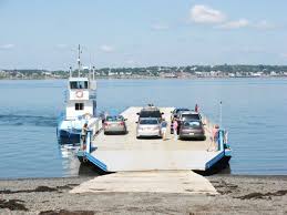
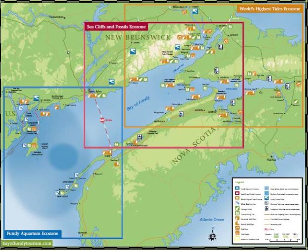
Campobello, a 15 square mile Canadian island in the Bay of Fundy and site of Franklin D. Roosevelt’s long-time summer home, lies 10 miles across open ocean from mainland New Brunswick but a mere 300 yards from the U.S. mainland at Lubec, Maine.  Well, I decided to go back to Canada on purpose and got in the short line to Campobello Island (part of New Brunswick) and crossed the Franklin D. Roosevelt Bridge.  After a few cursory questions about what we were carrying in the car, we were granted admission into Canada.

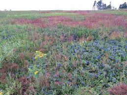
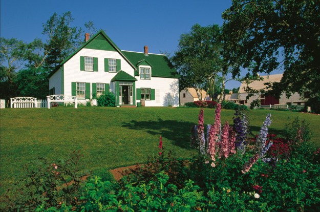
I quickly encountered the Roosevelt Campobello International Park, a combination indoor/outdoor site that includes the FDR summer home and a 1,133-hectare (2,800-acre) natural area. The Natural Area’s gravel roads offer you an experience similar to that enjoyed by the Roosevelt family when they came to Campobello. During that era, a system of carriage and surrey drives provided access to points of interest in what is now Roosevelt Campobello International Park or Herring Cove Provincial Park.  Top down, we explored the park’s many roadways (all extremely narrow and dirt or gravel) and even experienced some of the shorter hikes.  My car is filthy!

Campo8

We walked around FDR’s summer residence and decided to stop for lunch at The Prince Café in the park.  That salad you see is full of fresh blueberries, raspberries, and strawberries, pecans, and goat cheese, all topped with poppyseed dressing.  It was yummy!

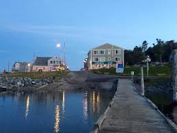
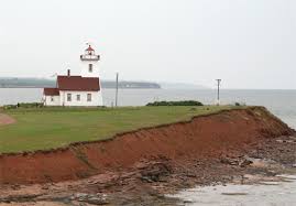
We then decided to explore further and discovered the Head Harbor Light Station and, as we visited as the tides were coming in (at about 3:00 PM), we got these pictures.  Just so you know, today, at 5:29 AM the tides rose to an impressive 21.75 feet yet at 11:46 AM, low tide was at 2.30 feet so, as you can see, in a space of just six hours, the tides change almost 20 feet!  I can certainly understand the posted warnings about climbing down the ladders and walking across to the lighthouse.  If I didn’t have Chloe with me, I may have made plans to come back at extreme low tide to see about crossing (as long as other people were there with me.  I’m not brave enough to do something like that alone).  It’s probably just as well.

Driving back into the United States, I, of course, had to go through the Border Patrol gate where I found the agents (both yesterday and today) to be very friendly, informative, and welcoming.

Lubec15

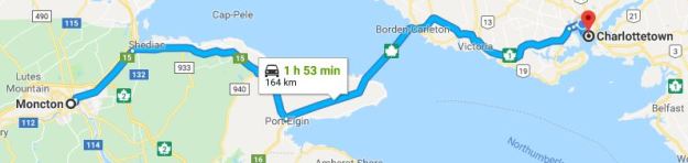
So, I am here in Lubec for another night then tomorrow morning am off to Lutes Mountain in New Brunswick.  Chloe is completely out of it.  She crashed once we came back to our room and has been like this for the past hour or so—I guess she got a little too much exercise today.

Lobster

After Chloe napped for a while, we went down to dinner.  This inn’s restaurant reminds me a little of Martine’s in New Hope.  It’s a small bar with just a few dining tables but I’m not talking about appearances…it’s the ambiance and the friendliness one feels when you walk in.  Lots of locals show up and tourists such as myself are accepted and included in conversation.  The wait staff remembers you (and I have only been here one day) and it’s definitely a feel-good situation.  So, tonight, I ordered the lobster roll (I am in Maine after all).  Look at how much chunk lobster meat was included!  I know that today I walked more than five miles but if I keep eating like this, I’ll have to walk ten miles!

So, people in Maine use some unusual words but one in particular aroused my curiosity: “downeast”.  What does it mean and where did it come from?  On www.downeast.com, I found this explanation:  As Colin Woodard explained in his book The Lobster Coast, “the prevailing winds on the Maine coast blow from the southwest in the warm months, so ships from Boston were able to run downwind as they sailed along Maine’s north-easterly-trending coast.”’  Ok.  That may be an explanation, but I’m still confused.

Maine

Despite that, I found Maine to be a treasure with its rolling mountains, craggy cliffs, fishing villages, picturesque waterways, and the amazing array of seafood found everywhere.  Some interesting facts…Maine is both the northernmost state in New England and the largest, accounting for almost half the region’s entire land area. Maine is the only state to border exactly one other state (New Hampshire to the west).  It is also the easternmost state in the United States in both its extreme points and its geographic center.  Maine has the highest percentage of French Americans among American states and consider French to be their secondary language.  Maine is the least densely populated U.S. state east of the Mississippi River. It is called the Pine Tree State; about 83% of its land is forested, the most forested cover of any state.  I think I can attest to that last fact as I drove through Maine for many hours with the sweet smell of pine permeating my senses.

“Life must be lived and curiosity kept alive. One must never, for whatever reason, turn his back on life.”                 Eleanor Roosevelt


July 18, 2018 Lubec, Maine

Leg 17

Scenery wise—I don’t think today can be topped.  The day started out with a gorgeous sun brightening our azure blue skies with a delightfully cool breeze, a perfect day for the top down.  Acadia National Park was put in place to protect the natural beauty of the highest rocky headlands along the Atlantic coastline of the United States, an abundance of habitats with high biodiversity, clean air and water, and a rich cultural heritage. Each year, more than 3.3 million people explore seven peaks above 1,000 feet, 158 miles of hiking trails, and 45 miles of carriage roads with 16 stone bridges.

Acadia6

The primary avenue for navigating through this park on Mount Desert Island is the Park Loop Road, a 27-mile road that begins at the Hulls Cove Visitor Center (near Route 3 on the northern side of the island) and connects the Park’s lakes, mountains, forests, and rocky coast.  I had planned to drive the loop yesterday but with the heavy fog, figured I’d wait until this morning and I’m glad I did.  We set out shortly after 8:00 AM and the roads were already filling with hikers, bikers, bicyclists, and other drivers but luckily, the park provides many places to pull over and soak in the scenery.  I think you would have to work very hard to find any area that is not photogenic.

My only disappointment was that I would have liked to hike the trails as they look challenging and usually lead to sections of the park not visible from the loop.  Chloe is not the best hiker.  She seems game for about a mile but even then, she wants to investigate every smell, so it is slow going.

Once we left the park, our route today was mostly along Route 1 and, while much of the road surface could definitely use some repair, the views were mostly magnificent.  I must admit thinking that New Hampshire, with no sales tax and an income tax on interest and dividends (not earned income), somehow manages to have better paved roads than Maine, who has a 5.5%-8% sales tax (depending on what you buy) and an income tax on 5.8%-7.15% on all income.

Blueberries1

Blueberries

I discovered that Maine is one of America’s largest blueberry-growing states, raising 90% of the low-bush blueberries in North America. Sixty thousand acres in production produces a harvest of over 75 million pounds, the major proportion of which is raked in Washington County (which is where I am tonight). Many families from Lubec participate in blueberry raking. The prized, antioxidant-rich berries are harvested in the month of August and early September.  Blueberries and their products are sold everywhere.  Yum—love blueberries!  And, this is what I had for dessert tonight…blueberry crumble with freshly made blueberry ice cream–and yes, I already started eating it–Very good!

Lubec4

Driving into Lubec, I knew I was going to fall in love!  Located on a peninsula in Passamaquoddy Bay, slightly south of Eastport, it is the easternmost city in the U.S.A. and I am staying in the easternmost inn!

 Cohills In          Cohills1

The population as of the last census was 1,359 so it is a small town.  Settled in 1785 and incorporated in 1811, Lubec was once a proud and bustling sardine canning and fish-smoking center. It was here in the Quoddy region that America’s sardine processing industry was created.  Today, self-employed persons (many of them artisans) and the service industry seem to dominate the economy.

Our room is on the third floor (while that may be a slight drawback), we are experiencing a beautiful breeze off the water and we are high enough that no one can see into the room, so I can keep the windows open.  Air conditioning, while available, is not necessary.  Look at the views above—that, by the way, is Canada!

Lubec is a gateway to neighboring Campobello Island, New Brunswick Canada. Even Canadians cannot get there as easily as we can—there is a bridge from Lubec which I inadvertently almost crossed when I made a wrong turn!  (I had to do a u-turn to get out of line.) Canadians either have to drive to the U.S. and cross our bridge or they can take a ferry from Deer Crossing in New Brunswick to Campbobello.  Now that I know about this ferry, I may look into it.

Lubec3